
IMAGES TAKEN NEAR TO
First Avenue, TELFORD, TF2 0AG
Introduction
This page details the photographs taken nearby to First Avenue, TF2 0AG by members of the Geograph project.
The Geograph project started in 2005 with the aim of publishing, organising and preserving representative images for every square kilometre of Great Britain, Ireland and the Isle of Man.

There are currently over 7.5m images from over14,400 individuals and you can help contribute to the project by visiting https://www.geograph.org.uk
Image Map
Images are licensed for reuse under creativecommons.org/licenses/by-sa/2.0
Notes
- Clicking on the map will re-center to the selected point.
- The higher the marker number, the further away the image location is from the centre of the postcode.
Image Listing (43 Images Found)
Images are licensed for reuse under creativecommons.org/licenses/by-sa/2.0
Image
Details
Distance
1
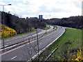
Queensway, Telford
The A442 Queensway (aka The Eastern Primary) looking South from the Greyhound Interchange towards the centre of Telford. A quiet moment for once, as the main "spine" road across Telford, it is usually fairly busy during the day.
Image: © Gordon Cragg
Taken: 26 Mar 2009
0.07 miles
2
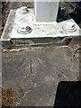
OS rivet benchmark - Greyhound Island
A slightly clearer photo than Image, and I'd maintain that part of the rivet is still visible. That's not to excuse the clumsy placement of the concrete pad for the fence.
Image: © Richard Law
Taken: 3 Jun 2023
0.09 miles
3
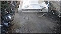
Rivet Benchmark
A Rivet Benchmark cut into the surface above an underpass. The Rivet has been lost under the support for a barrier. Only the Crow's Foot is now visible
Image: © Anthony Rowley
Taken: 22 Apr 2021
0.09 miles
4
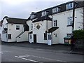
The Stafford Arms, Ketley Bank
Quite a big pub but closed at lunchtime when I walked past.
Image: © Mike White
Taken: 14 Jan 2009
0.11 miles
5
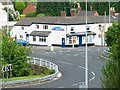
The Greyhound Inn
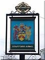
The Greyhound Inn, Holyhead Road, is named on the 1889 map. Like the road that passes its front door (the old A5, now B5061) it has given up its name (to the roundabout). It now sells pizza, not ale, though the inn sign (suitably amended) remains.
Image: © Mike White
Taken: 30 May 2008
0.11 miles
7
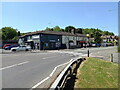
The former Greyhound Inn
As described in Image some years ago, the old Greyhound Inn here is no more, although the takeaway/delivered pizza business continues to flourish. There have been some minor changes to the building since 2008, including the loss of the porch and its flanking bay windows, and the old pub sign has now gone for a burton.
Image: © Richard Law
Taken: 3 Jun 2023
0.12 miles
8
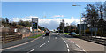
Holyhead Road, Snedshill, Oakengates
Looking East along the Holyhead Road (former A5) from the Greyhound roundabout, towards Snedshill. The site on the left was the former Lilleshall Company's Brick and Sanitary Ware factory. After the old buildings were destroyed in a fire the site was cleared and permission obtained for a Wickes DIY store. Work appears to have come to a stop, possibly because of the economic situation. The junction on the right is a link road down to the A442 Eastern Primary road (Queensway) which runs under where the photographer is standing.
Image: © Gordon Cragg
Taken: 26 Mar 2009
0.12 miles
9
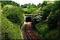
Oakengates Railway Tunnel
The Southern entrance to the Oakengates railway tunnel. Built in the 1840s to Broad Gauge dimensions although Broad Gauge track never reached this far. It is the furthest North of any structure built for Brunel's brainchild. The North end is here-- Image
Image: © Gordon Cragg
Taken: 26 May 2003
0.13 miles
10
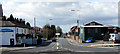
Holyhead Road, Oakengates
The "old" A5, The Holyhead Road looking West from the Greyhound Island. The former Greyhound Pub, now a Pizza takeaway,is on the left.
Image: © Gordon Cragg
Taken: 26 Mar 2009
0.14 miles