IMAGES TAKEN NEAR TO
TELFORD, TF1 6QN
Introduction
This page details the photographs taken nearby to TF1 6QN by members of the Geograph project.
The Geograph project started in 2005 with the aim of publishing, organising and preserving representative images for every square kilometre of Great Britain, Ireland and the Isle of Man.

There are currently over 7.5m images from over14,400 individuals and you can help contribute to the project by visiting https://www.geograph.org.uk
Image Map (Loading...)


Getting Data...Please wait
Leaflet Map data © OpenStreetMap
Images are licensed for reuse under creativecommons.org/licenses/by-sa/2.0
Notes
- Clicking on the map will re-center to the selected point.
- The higher the marker number, the further away the image location is from the centre of the postcode.
Image Listing (8 Images Found)
Images are licensed for reuse under creativecommons.org/licenses/by-sa/2.0
Image
Details
Distance
1
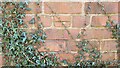
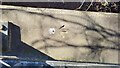
Rear of 43 Cheltenham Court
The Ordnance Survey Datum Line Benchmark with Crow's Foot cut into the wall to the rear of 43 Cheltenham Court, Telford. The Third Order Benchmark was both levelled and last verified by the OS in 1985. The recorded height AODN is 77.609-metres.
Image: © Anthony Rowley
Taken: 14 Mar 2022
0.04 miles
2
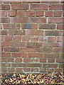
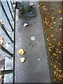
OS benchmark - Leegomery, wall at rear of 43 Cheltenham Court
An OS cutmark on the rear wall of the garden of a house in Cheltenham Court; originally levelled in 1984 at 77.609m above Ordnance Datum Newlyn.
Image: © Richard Law
Taken: 18 Oct 2015
0.04 miles
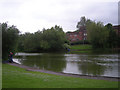
4
Thomas Telford, Leegomery
Large Greenalls estate pub - John Smiths the beer
Image: © al partington
Taken: 15 Mar 2006
0.13 miles
5
Pool Farm Avenue Subway Parapet
The Ordnance Survey Rivet Benchmark set into parapet of a subway on Pool Farm Avenue in Leegomery, Telford. The accompanying Crow's Foot is slightly damaged. The benchmark was set with a Third Order level of accuracy and was levelled & (last) verified in 1984. The reported height AODN is 80.066-metres.
Image: © Anthony Rowley
Taken: 14 Mar 2022
0.15 miles
6
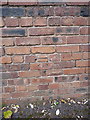
OS rivet - Leegomery, Pool Farm Drive bridge
An OS rivet on the parapet of an underpass bridge on Pool Farm Way; originally emplaced in 1984 at 80.066m above Ordnance Datum Newlyn.
Image: © Richard Law
Taken: 18 Oct 2015
0.15 miles
7
OS benchmark - Leegomery, wall beside Grainger Drive
An OS cutmark on the rear garden wall of a house (27 Epsom Court) which backs onto Grainger Drive; originally cut by the OS in 1984 at 82.676m above Ordnance Datum Newlyn.
Image: © Richard Law
Taken: 18 Oct 2015
0.20 miles
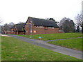
8
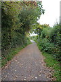
Old lane through to Leegomery
The line of the former road between Wellington and Leegomery Hall, now 'downgraded' to a footpath through the modern housing estates of north Telford.
Image: © Richard Law
Taken: 18 Oct 2015
0.22 miles