IMAGES TAKEN NEAR TO
Queensway, TELFORD, TF1 6AJ
Introduction
This page details the photographs taken nearby to Queensway, TF1 6AJ by members of the Geograph project.
The Geograph project started in 2005 with the aim of publishing, organising and preserving representative images for every square kilometre of Great Britain, Ireland and the Isle of Man.

There are currently over 7.5m images from over14,400 individuals and you can help contribute to the project by visiting https://www.geograph.org.uk
Image Map (Loading...)


Getting Data...Please wait
Leaflet Map data © OpenStreetMap
Images are licensed for reuse under creativecommons.org/licenses/by-sa/2.0
Notes
- Clicking on the map will re-center to the selected point.
- The higher the marker number, the further away the image location is from the centre of the postcode.
Image Listing (6 Images Found)
Images are licensed for reuse under creativecommons.org/licenses/by-sa/2.0
Image
Details
Distance
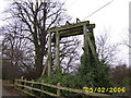
2
Turnip Lock gates at Hadley
These are the remains of the "turnip lock" gates on the Shrewsbury Canal at Hadley. This lock is the second lock in this area. It is situated approximately 50 yards from the Silkin Way path.
Image: © Roger Dean
Taken: 20 Oct 2005
0.13 miles
3
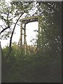
Guillotine Locks
This is a guillotine style lock on the disused Telford tubboat canal at Hadley Park in Telford
Image: © Mr M Evison
Taken: 5 Feb 2006
0.19 miles
4
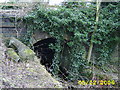
Canal Bridge
This is a canal bridge at Hadley Park, Telford
Image: © Mr M Evison
Taken: 5 Feb 2006
0.19 miles
6
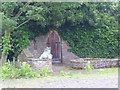
A door that leads nowhere!
A mysterious door opposite Hadley Park House Hotel
Image: © A Holmes
Taken: 19 May 2007
0.24 miles