IMAGES TAKEN NEAR TO
Red Lees, TELFORD, TF1 5DG
Introduction
This page details the photographs taken nearby to Red Lees, TF1 5DG by members of the Geograph project.
The Geograph project started in 2005 with the aim of publishing, organising and preserving representative images for every square kilometre of Great Britain, Ireland and the Isle of Man.

There are currently over 7.5m images from over14,400 individuals and you can help contribute to the project by visiting https://www.geograph.org.uk
Image Map (Loading...)


Getting Data...Please wait
Leaflet Map data © OpenStreetMap
Images are licensed for reuse under creativecommons.org/licenses/by-sa/2.0
Notes
- Clicking on the map will re-center to the selected point.
- The higher the marker number, the further away the image location is from the centre of the postcode.
Image Listing (37 Images Found)
Images are licensed for reuse under creativecommons.org/licenses/by-sa/2.0
Image
Details
Distance
1
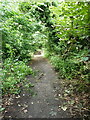
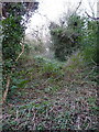
An old trackway behind Ketley Hall
Old maps aren't clear as to the purpose (or even the existence) of this track, which drops down from south to north in the general direction of the road named Red Lees. Part way down it, there's some crumbling masonry on either side, which may be the disintegrating remains of a bridge carrying an 18th century mining tramway from east-west; the whole area was heavily mined for coal, limestone and some poor iron ore around that time. Most of the surface features, e.g. spoil heaps, which were mapped around 1900 in the area have now been re-landscaped or flattened during the 1960s/70s when the whole area was being built up as Telford New Town, so it's hard to find clear evidence of just what was what nowadays.
Image: © Richard Law
Taken: 1 Aug 2021
0.02 miles
2
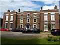
Ketley Hall
A remarkable survivor in the middle of the Telford New Town. Ketley Hall dates from the mid-late 18th century, and was at one time occupied by the Reynolds family; they were early ironmasters and ran a foundry nearby, along with a canal and inclined plane for the tub-boats which supplied coal & ironstone into said foundry. The house was Grade II listed https://britishlistedbuildings.co.uk/101038628-ketley-hall-ketley#.YZgfXNDP3IU & https://historicengland.org.uk/listing/the-list/list-entry/1038628 in 1971.
(The rather flash cars were visiting for a function at the hall, but I didn't feel I could ask them to move for the photo)
Image: © Richard Law
Taken: 1 Aug 2021
0.05 miles
3
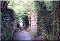
Red Lees, Ketley
Looking down the Red Lees footpath that runs from Red Lake to Ketley. The old bridge abutments used to carry a tramway across to the coal spoil heaps, now all overgrown.
Image: © Gordon Cragg
Taken: Unknown
0.08 miles
4
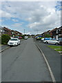
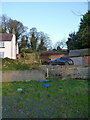
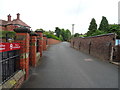
The Incline (road) at Ketleyhill
Clearly not an incline in itself, as it's more or less level. But it appears to take its name from the nearby Image which lies immediately to the NW (ie directly behind me in this photo). The houses here look like they were built in the 1960s or early 1970s, which would tie in with the most active period of development of Telford New Town, during which much of the former industrial archeology of the area was lost.
Image: © Richard Law
Taken: 1 Aug 2021
0.08 miles
5
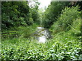
The last remaining stretch of the Ketley Canal
The canal was dug in the late 18th century as a link to carry coal and ironstore between the Shropshire Canal at Oakengates, and a private foundry near Ketley. It operated as such for roughly 30 years, and included the use of an inclined plane at the western end, which is likely to be the feature seen in Image via which the loaded tub boats were lowered on rails to the foundry. See also Image taken nearly 20 years previously, when the water was a little less vegetated.
Image: © Richard Law
Taken: 1 Aug 2021
0.09 miles
6
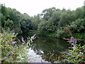
Remains of Ketley Canal
The last remnant of the Ketley canal in Paddock Mount, Ketley. This was built in 1788 by William Reynolds, a local Ironmaster, it ran to his iron foundry at Ketley from a junction with the Shropshire canal near Oakengates. Image
Image: © Gordon Cragg
Taken: 12 Aug 2003
0.09 miles
7
Another possible location for the vanished Ketley Inclined Plane
If Image isn't the exact route of the one-time Ketley Incline, then this wooded slope is another possibility (it's just offshot to the left of that picture, in the trees behind the white farmhouse). This fairly steep slope lies immediately uphill of Image, but local information suggests that the pool is not what I have speculated.
Image: © Richard Law
Taken: 1 Jan 2022
0.11 miles
8
The most probable site of the Ketley Inclined Plane
Possibly the first successfully-operated and commercially viable Inclined Plane in the UK, built around 1788 as a means of lowering tub boats from the Ketley Canal Image to a long-vanished foundry just to the NW of this point. The boats carried coal and ironstone to the foundry, and were lowered on L-shaped rails with a braking system managed via a windlass at the top of the plane.
There seems to be very little (reliable) documented evidence of the exact route of the incline, and if any trace remained 'on the ground' into the 20th century it has been removed by a combination of garden landscaping in the grounds of Hillside Farm on the left here, plus the efforts of Telford Development Corporation from the 1960s onwards. However, a combination of detective work using the best available old maps that we can find, plus some local knowledge from the long-term residents of the farm, suggest that the centre of this photo (ie through the car and the brick outbuilding behind it) tracks the most probable line of the incline. At the top of the garden there is a fence, immediately behind which lies the road bearing the name Image
Image: © Richard Law
Taken: 1 Jan 2022
0.11 miles
10
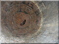
Brick-lined chamber in the tunnel
Roughly 20 yards inside Image lies this well-built chamber, which is about 15 or 18 feet high. It's immediately under the back garden of Hillside Farm. To the left of the point I took this picture (which is looking more or less directly upwards) there's another arm of the tunnel which apparently leads to a further identical chamber a little further on, before heading onwards in the direction of Ketley Hall. All very mysterious at the moment.
Image: © Richard Law
Taken: 1 Jan 2022
0.12 miles