IMAGES TAKEN NEAR TO
Sheinton Road, MUCH WENLOCK, TF13 6NT
Introduction
This page details the photographs taken nearby to Sheinton Road, TF13 6NT by members of the Geograph project.
The Geograph project started in 2005 with the aim of publishing, organising and preserving representative images for every square kilometre of Great Britain, Ireland and the Isle of Man.

There are currently over 7.5m images from over14,400 individuals and you can help contribute to the project by visiting https://www.geograph.org.uk
Image Map
Images are licensed for reuse under creativecommons.org/licenses/by-sa/2.0
Notes
- Clicking on the map will re-center to the selected point.
- The higher the marker number, the further away the image location is from the centre of the postcode.
Image Listing (6 Images Found)
Images are licensed for reuse under creativecommons.org/licenses/by-sa/2.0
Image
Details
Distance
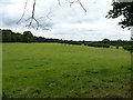
1
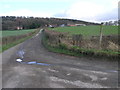
Footpath to the Farm
This footpath passes by the farm on the hill and splits off in different directions passing through the trees on the horizon which are known as Traps Coppice.
Image: © Michael Patterson
Taken: 1 Mar 2007
0.03 miles
2
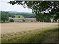
Seven Springs Farm
With the lane to Sheinton in the distance beyond it.
Image: © Richard Law
Taken: 2 Aug 2010
0.05 miles
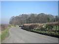
6
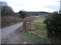
Lane to Much Wenlock
Seven Springs Farm in the distance.
Image: © Row17
Taken: 6 Mar 2008
0.24 miles