IMAGES TAKEN NEAR TO
Blakeway Hollow, MUCH WENLOCK, TF13 6AR
Introduction
This page details the photographs taken nearby to Blakeway Hollow, TF13 6AR by members of the Geograph project.
The Geograph project started in 2005 with the aim of publishing, organising and preserving representative images for every square kilometre of Great Britain, Ireland and the Isle of Man.

There are currently over 7.5m images from over14,400 individuals and you can help contribute to the project by visiting https://www.geograph.org.uk
Image Map
Images are licensed for reuse under creativecommons.org/licenses/by-sa/2.0
Notes
- Clicking on the map will re-center to the selected point.
- The higher the marker number, the further away the image location is from the centre of the postcode.
Image Listing (44 Images Found)
Images are licensed for reuse under creativecommons.org/licenses/by-sa/2.0
Image
Details
Distance
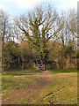
2
Blakeway Hollow
The lower, tarred part of what becomes a very attractive limestone floored green lane.
Image: © Richard Webb
Taken: 21 Jul 2019
0.03 miles
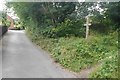
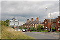
3
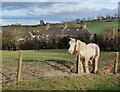
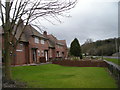
Horse next to the car park at Leasow Field
The houses are along Stretton Road in Much Wenlock.
Image: © Mat Fascione
Taken: 25 Mar 2023
0.07 miles
4
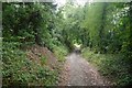
Blakeway Hollow
A green lane leading up to Wenlock Edge from Much Wenlock. How we got the minibus up it when working here in the 1980's?
Image: © Richard Webb
Taken: 21 Jul 2019
0.07 miles
5
Path to Shropshire Way
Looking from the National Trust's Wenlock Edge car park to the gate and steps which lead to the Shropshire Way long-distance footpath.
Image: © David Dixon
Taken: 2 Mar 2012
0.07 miles
6
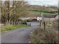
Road to the car park at Leasow Field
The houses are along Stretton Road in Much Wenlock.
Image: © Mat Fascione
Taken: 25 Mar 2023
0.08 miles
8
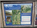
National Trust Information Board at Wenlock Edge (2)
Located at the edge of the Wenlock Edge car park off the B4371 Stretton Road TF13 6AS, this information board shows two maps of the Wenlock Edge with two images to the left of the maps. The wording at the top of the information board has the following wording:
Welcome to Wenlock Edge
Wenlock Edge is a rare and special landscape formed 425 million years ago as a coral reef in a shallow sea. It stretches in an unbroken line for 18 miles (30km) between Ironbridge and Craven Arms in Shropshire and it is often described as a great wave about to break. This thickly wooded limestone escarpment offers dramatic vistas from dappled paths, glimpses of its industrial past with historic quarries and limekilns; you'll also discover abundant fossils, rare flowers and lots of wildlife along this special landscape.
To the right of the noticeboard is the following wording:
The Much Wenlock National Trust car park sits in an old quarry called Kiln Leasow field. Within the rock face here you'll see the bedded Wenlock Limestone dipping towards the road where it disappears beneath the softer, overlying Lower Ludlow Shales.
Until the 1840s local farmers quarried and burnt the limestone here to spread on their fields as a soil conditioner. Today the limestone grassland supports a rich variety of flowering plants, including several species of orchid.
Walks
There are seven waymarked circular routes across Wenlock Edge, the others start from Presthope Car Park and Wilderhope Manor. Two of the walks start from this car park.
Major's Leap Walk
This walk is along woodland paths with panoramic views along the way.
Distance: 5.5km (3.4miles)
Duration: 2 hours
Difficulty: Medium
Jenny Wind Walk
This walk is along woodland paths and part of the old tramway. In Spring and early Summer the flower rich meadows are beautiful.
Distance: 3.5km (2.2miles)
Duration: 1.5 hours
Difficulty: Easy-Medium
Image: © David Hillas
Taken: 20 Jul 2018
0.08 miles
10
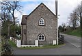
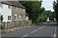
Old Toll House, Much Wenlock
Toll House in the parish of Much Wenlock, at Wenlock Bank on Stretton Road (B4371).
Surveyed
Milestone Society National ID: SA.MUW01
Image: © Milestone Society
Taken: Unknown
0.09 miles