IMAGES TAKEN NEAR TO
Bickerstaff Court, TELFORD, TF1 2HL
Introduction
This page details the photographs taken nearby to Bickerstaff Court, TF1 2HL by members of the Geograph project.
The Geograph project started in 2005 with the aim of publishing, organising and preserving representative images for every square kilometre of Great Britain, Ireland and the Isle of Man.

There are currently over 7.5m images from over14,400 individuals and you can help contribute to the project by visiting https://www.geograph.org.uk
Image Map
Images are licensed for reuse under creativecommons.org/licenses/by-sa/2.0
Notes
- Clicking on the map will re-center to the selected point.
- The higher the marker number, the further away the image location is from the centre of the postcode.
Image Listing (67 Images Found)
Images are licensed for reuse under creativecommons.org/licenses/by-sa/2.0
Image
Details
Distance
1
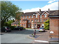
The Wrekin Professional Centre
Originally built in the mid 1870s as the Wellington Union Workhouse, replacing a site closer to the centre of Wellington Image The site became a Public Assistance Institution in the 1930s, and in the late 1940s, the Wrekin Hospital. After a period as a nursing home, it now houses a number of medical and care businesses.
Image: © Richard Law
Taken: 1 May 2020
0.06 miles
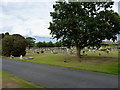
2
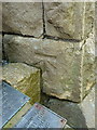
OS benchmark - Wellington, cemetery chapel
An OS cutmark on the east side of the chapel in the town cemetery; originally levelled in 1938 at 108.96m above Ordnance Datum Newlyn.
Image: © Richard Law
Taken: 5 Jul 2014
0.08 miles
3

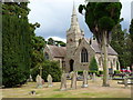
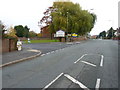
Appledore Gardens, Wellington
Viewed across Wrekin Road.
Image: © Jaggery
Taken: 10 Oct 2013
0.09 miles
5
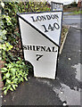
The Wellington milepost - detail
Detail of the milepost seen in Image beside the old A5 coach road from London to Holyhead.
Image: © Richard Law
Taken: 31 Oct 2010
0.10 miles
6
The Wellington milepost in its setting
A view along the 'old' A5, Watling Street, looking eastwards, with Image outside the former hospital.
Image: © Richard Law
Taken: 31 Oct 2010
0.10 miles
8
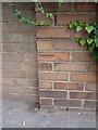
OS benchmark - Wellington, Holyhead Road
An OS cutmark on a roadside wall, north side of Holyhead Road; originally levelled at 117.577m above Ordnance Datum Newlyn.
Image: © Richard Law
Taken: 5 Jul 2014
0.10 miles
9
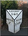
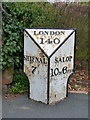
Old Milepost by the B5061, Holyhead Road, Wellington
Cast iron post by the B5061 (former A5), in parish of Wellington (Telford and Wrekin District), Holyhead Road, Wellington, junction with Pooler Close, South of old hospital on pavement, on North side of road. Erected by the Watling Street, Wellington District turnpike trust in the 19th century.
Inscription reads:-
: SHIFNAL / 7 : : LONDON / 140 : : SALOP / 10M 6FUR :
Grade II listed.
List Entry Number: 1033320 https://historicengland.org.uk/listing/the-list/list-entry/1033320
Milestone Society National ID: SA_SFSB07
Image: © A Reade/M Faherty
Taken: 10 Feb 2008
0.10 miles
10
Old Milepost by the B5061, Holyhead Road, Wellington
Cast iron post by the B5061 (former A5), in parish of Wellington (Telford and Wrekin District), Holyhead Road, Wellington, junction with Pooler Close, South of old hospital on pavement, on North side of road. Erected by the Watling Street, Wellington District turnpike trust in the 19th century.
Inscription reads:-
: SHIFNAL / 7 : : LONDON / 140 : : SALOP / 10M 6FUR :
Grade II listed.
List Entry Number: 1033320 https://historicengland.org.uk/listing/the-list/list-entry/1033320
Milestone Society National ID: SA_SFSB07
Image: © Gail Fawcett
Taken: 21 Oct 2023
0.10 miles