
IMAGES TAKEN NEAR TO
Ercall Lane, TELFORD, TF1 2DY
Introduction
This page details the photographs taken nearby to Ercall Lane, TF1 2DY by members of the Geograph project.
The Geograph project started in 2005 with the aim of publishing, organising and preserving representative images for every square kilometre of Great Britain, Ireland and the Isle of Man.

There are currently over 7.5m images from over14,400 individuals and you can help contribute to the project by visiting https://www.geograph.org.uk
Image Map
Images are licensed for reuse under creativecommons.org/licenses/by-sa/2.0
Notes
- Clicking on the map will re-center to the selected point.
- The higher the marker number, the further away the image location is from the centre of the postcode.
Image Listing (53 Images Found)
Images are licensed for reuse under creativecommons.org/licenses/by-sa/2.0
Image
Details
Distance
1
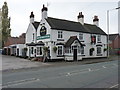
The Red Lion Inn, Holyhead Road, Wellington
A free house on the old A5 through Wellington.
Image: © Richard Law
Taken: 31 Oct 2010
0.09 miles
2
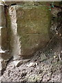
OS benchmark - Wellington, Ercall Lane
An OS cutmark on a garden wall at the entrance to a house called Brackenwood on the west side of Ercall Lane; originally levelled in 1958 at 140.099m above Ordnance Datum Newlyn.
Image: © Richard Law
Taken: 5 Jul 2014
0.11 miles
3
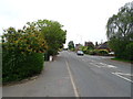
Holyhead Road, Wellington
Looking east on the B5061.
Image: © JThomas
Taken: 18 May 2019
0.12 miles
4
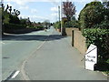
Salop 10 And 6 Furlongs
Milepost on what would have been the A5 near to Wellington; for close up view see http://www.geograph.org.uk/photo/4950856
Image: © Keith Evans
Taken: 23 Apr 2016
0.13 miles
5
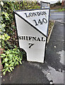
Old Milepost by the B5061, Holyhead Road, Wellington
Cast iron post by the B5061 (former A5), in parish of Wellington (Telford and Wrekin District), Holyhead Road, Wellington, junction with Pooler Close, South of old hospital on pavement, on North side of road. Erected by the Watling Street, Wellington District turnpike trust in the 19th century.
Inscription reads:-
: SHIFNAL / 7 : : LONDON / 140 : : SALOP / 10M 6FUR :
Grade II listed.
List Entry Number: 1033320 https://historicengland.org.uk/listing/the-list/list-entry/1033320
Milestone Society National ID: SA_SFSB07
Image: © Gail Fawcett
Taken: 21 Oct 2023
0.13 miles
6
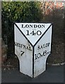
Old Milepost by the B5061, Holyhead Road, Wellington
Cast iron post by the B5061 (former A5), in parish of Wellington (Telford and Wrekin District), Holyhead Road, Wellington, junction with Pooler Close, South of old hospital on pavement, on North side of road. Erected by the Watling Street, Wellington District turnpike trust in the 19th century.
Inscription reads:-
: SHIFNAL / 7 : : LONDON / 140 : : SALOP / 10M 6FUR :
Grade II listed.
List Entry Number: 1033320 https://historicengland.org.uk/listing/the-list/list-entry/1033320
Milestone Society National ID: SA_SFSB07
Image: © A Reade/M Faherty
Taken: 10 Feb 2008
0.13 miles
7
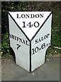
Old Milepost
Milepost on what would have been the A5 near to Wellington, for overall view see http://www.geograph.org.uk/photo/4950866
Image: © Keith Evans
Taken: 23 Apr 2016
0.13 miles
8
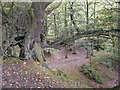
Ercall Wood Nature Reserve
Formerly the area was quarried, but has now recovered and is covered with mainly oak trees. The hill is north-east of the larger Wrekin hill, and is made of granophyre, a dark pink igneous rock. The northern end of the hill has been cut through by the M54.
Image: © Bob Bowyer
Taken: 20 Sep 2003
0.13 miles
9
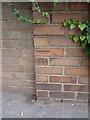
OS benchmark - Wellington, Holyhead Road
An OS cutmark on a roadside wall, north side of Holyhead Road; originally levelled at 117.577m above Ordnance Datum Newlyn.
Image: © Richard Law
Taken: 5 Jul 2014
0.13 miles
10
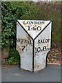
The Wellington milepost - detail
Detail of the milepost seen in Image beside the old A5 coach road from London to Holyhead.
Image: © Richard Law
Taken: 31 Oct 2010
0.13 miles