IMAGES TAKEN NEAR TO
Saville Close, TELFORD, TF1 2DG
Introduction
This page details the photographs taken nearby to Saville Close, TF1 2DG by members of the Geograph project.
The Geograph project started in 2005 with the aim of publishing, organising and preserving representative images for every square kilometre of Great Britain, Ireland and the Isle of Man.

There are currently over 7.5m images from over14,400 individuals and you can help contribute to the project by visiting https://www.geograph.org.uk
Image Map (Loading...)


Getting Data...Please wait
Leaflet Map data © OpenStreetMap
Images are licensed for reuse under creativecommons.org/licenses/by-sa/2.0
Notes
- Clicking on the map will re-center to the selected point.
- The higher the marker number, the further away the image location is from the centre of the postcode.
Image Listing (117 Images Found)
Images are licensed for reuse under creativecommons.org/licenses/by-sa/2.0
Image
Details
Distance
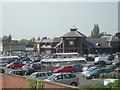
2
Morrisons Supermarket
Morrisons garage (supermarket is off to the right) - built on Wellington's old cattle market. In the middle distance are new houses built on the site of the town's gas works and railway yards. In the distance is the Wrekin (Pre-Cambrian hill rising to just over 407 metres) TV mast built on top.
Image: © Bob Bowyer
Taken: 22 Sep 2005
0.10 miles
4
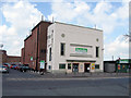
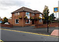
Former Clifton Cinema, Wellington
The former (and well loved) Clifton cinema, Bridge Road, Wellington. Now a soft furnishing emporium.
Image: © Gordon Cragg
Taken: 22 Apr 2009
0.11 miles
5
Blink in Wellington
Blink Opticians are in Spectrum House on the corner of Bridge Road and Groom's Alley.
Image: © Jaggery
Taken: 10 Oct 2013
0.11 miles
6
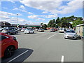
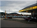
Supermarket carpark
Customer parking outside the Morrison's supermarket in Wellington
Image: © Richard Law
Taken: 6 Aug 2022
0.11 miles
7
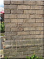
OS benchmark - Wellington, The Haygate pub
A clear OS cutmark on the wall of The Haygate pub; originally levelled in 1966 at 96.55m above Ordnance Datum Newlyn. Updated note Jan 2019 - this mark has probably now been destroyed. The current edition of the local paper reports that the pub is being demolished this week, and the mark's quite likely a goner as a result. (I can confirm in 2022 that is the case; the pub has now been demolished)
Image: © Richard Law
Taken: 5 Jul 2014
0.12 miles
9
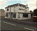
Smithfields Wellington
Fish & chips restaurant and takeaway on the corner of Bridge Street and Ten Tree Croft.
Image: © Jaggery
Taken: 10 Oct 2013
0.13 miles
10
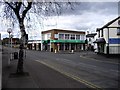
Junction of Market Street and Bridge Street
Image: © PAUL FARMER
Taken: 5 Apr 2009
0.13 miles