IMAGES TAKEN NEAR TO
Haygate Road, TELFORD, TF1 1RU
Introduction
This page details the photographs taken nearby to Haygate Road, TF1 1RU by members of the Geograph project.
The Geograph project started in 2005 with the aim of publishing, organising and preserving representative images for every square kilometre of Great Britain, Ireland and the Isle of Man.

There are currently over 7.5m images from over14,400 individuals and you can help contribute to the project by visiting https://www.geograph.org.uk
Image Map (Loading...)


Getting Data...Please wait
Leaflet Map data © OpenStreetMap
Images are licensed for reuse under creativecommons.org/licenses/by-sa/2.0
Notes
- Clicking on the map will re-center to the selected point.
- The higher the marker number, the further away the image location is from the centre of the postcode.
Image Listing (189 Images Found)
Images are licensed for reuse under creativecommons.org/licenses/by-sa/2.0
Image
Details
Distance
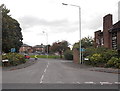
1

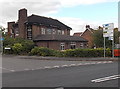
The Mount, Wellington
The central, redbrick part of this building is an early 19th century house. Its construction date is not recorded but it was Grade II listed https://britishlistedbuildings.co.uk/101033319-the-mount-wellington#.YvKVLnbMLIU & https://historicengland.org.uk/listing/the-list/list-entry/1033319 in 1983 and is now converted to flats and apartments.
Image: © Richard Law
Taken: 6 Aug 2022
0.02 miles
2
Peter Morris Cars, Wellington
Used car business viewed across Wrekin Road from the corner of Haygate Road.
Image: © Jaggery
Taken: 10 Oct 2013
0.04 miles
4
Taj Mahal, Wellington
Tandoori and Indian cuisine restaurant on the corner of Bridge Road and Walker Street.
The building used to be Porter's Ale House.
Image: © Jaggery
Taken: 10 Oct 2013
0.07 miles
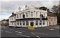
5
Wrekin Inn, Wellington
On the corner of Wrekin Road and Union Road.
Image: © Jaggery
Taken: 10 Oct 2013
0.07 miles
6
Union Street, Wellington
Viewed from Wrekin Road. The Wrekin Inn http://www.geograph.org.uk/photo/3705284 is on the right.
Image: © Jaggery
Taken: 10 Oct 2013
0.07 miles
7
Wellington: The Wrekin public house
Image: © Jonathan Hutchins
Taken: 1 Jun 2016
0.07 miles
8
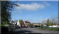
Three Way Junction, Wellington
The junction of Bridge Street, Wrekin Road and Victoria Road, Wellington.
Image: © Gordon Cragg
Taken: 21 Apr 2009
0.07 miles
9
Mid Counties Brokers, Wellington
Insurance brokers' office at 48A Walker Street.
Image: © Jaggery
Taken: 10 Oct 2013
0.07 miles
10
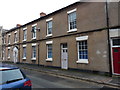
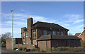
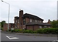
Site of the Wellington Workhouse, Walker Street
Probably not the original buildings of 1797, but this terrace of houses lies on the site of the Union Workhouse for the town, which was moved here from Street Lane (Watling Street) at that date. It was enlarged in the late 1830s or early 1840s to house up to 160 paupers, who would have been working at a variety of (rather menial) tasks such as cooking, cleaning, stone-breaking, animal husbandry, tailoring and so on. Workhouse life was not generally a happy one. The site was used later as offices by the Poor Law Union administrators, and subsequently as part of the Union Brewery.
The 1861 census of inmates records some comments and reasons for residency in the workhouse; these include "Old age and general debility", "Blind", "Unable to work in consequence of bad health" (all fair enough) but also "Had an illegitimate son", "An idiot from birth" and "A person of weak intellect"... these were undoubtedly different times.
In the mid 1870s, this building was replaced by a new, much larger workhouse on Street Lane (speculatively on the site of the original workhouse there) which is now used as The Wrekin Professional Centre, housing a number of care and medical facilities Image
Image: © Richard Law
Taken: 31 Jan 2019
0.08 miles