IMAGES TAKEN NEAR TO
Wrekin Road, TELFORD, TF1 1RN
Introduction
This page details the photographs taken nearby to Wrekin Road, TF1 1RN by members of the Geograph project.
The Geograph project started in 2005 with the aim of publishing, organising and preserving representative images for every square kilometre of Great Britain, Ireland and the Isle of Man.

There are currently over 7.5m images from over14,400 individuals and you can help contribute to the project by visiting https://www.geograph.org.uk
Image Map
Images are licensed for reuse under creativecommons.org/licenses/by-sa/2.0
Notes
- Clicking on the map will re-center to the selected point.
- The higher the marker number, the further away the image location is from the centre of the postcode.
Image Listing (151 Images Found)
Images are licensed for reuse under creativecommons.org/licenses/by-sa/2.0
Image
Details
Distance
1
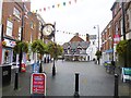
Wellington, Market Square
Now pedestrianised. Note the clock.
Image: © Mike Faherty
Taken: 13 Oct 2014
0.02 miles
3
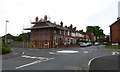
Wellington: mini-roundabout on Wrekin Road
Image: © Jonathan Hutchins
Taken: 1 Jun 2016
0.05 miles
4
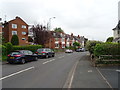
Wrekin Road, Wellington
Looking north east.
Image: © JThomas
Taken: 18 May 2019
0.05 miles
5
5 round holes in the wall, Roseway, Wellington
The holes are a design feature. Viewed from the Wrekin Road end of Roseway.
Image: © Jaggery
Taken: 10 Oct 2013
0.06 miles
6
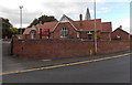
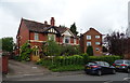
62 Wrekin Road, Wellington
Former Telford and Wrekin Council day care centre.
Image: © Jaggery
Taken: 10 Oct 2013
0.06 miles
7
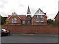
Tower, 62 Wrekin Road, Wellington
This is the NW corner of a former Telford and Wrekin Council day care centre.
Image: © Jaggery
Taken: 10 Oct 2013
0.06 miles
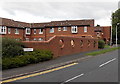
8
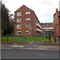
Hadrian Flats, Wellington
This is the Wrekin Road side of a block of flats.
Image: © Jaggery
Taken: 10 Oct 2013
0.07 miles
9
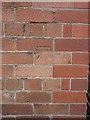
OS benchmark - Wellington, former Wrekin Road school
An OS cutmark on the wall of the former school in Wrekin Road (which is currently being converted to apartments). It was originally levelled in 1966 at 102.721m above Ordnance Datum Newlyn.
Image: © Richard Law
Taken: 5 Jul 2014
0.07 miles