IMAGES TAKEN NEAR TO
Linden Avenue, TELFORD, TF1 1QR
Introduction
This page details the photographs taken nearby to Linden Avenue, TF1 1QR by members of the Geograph project.
The Geograph project started in 2005 with the aim of publishing, organising and preserving representative images for every square kilometre of Great Britain, Ireland and the Isle of Man.

There are currently over 7.5m images from over14,400 individuals and you can help contribute to the project by visiting https://www.geograph.org.uk
Image Map
Images are licensed for reuse under creativecommons.org/licenses/by-sa/2.0
Notes
- Clicking on the map will re-center to the selected point.
- The higher the marker number, the further away the image location is from the centre of the postcode.
Image Listing (44 Images Found)
Images are licensed for reuse under creativecommons.org/licenses/by-sa/2.0
Image
Details
Distance
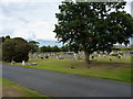
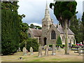
2
OS benchmark - Wellington, cemetery chapel
An OS cutmark on the east side of the chapel in the town cemetery; originally levelled in 1938 at 108.96m above Ordnance Datum Newlyn.
Image: © Richard Law
Taken: 5 Jul 2014
0.09 miles
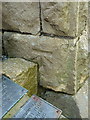
4
OS benchmark - Wellington, The Haygate pub
A clear OS cutmark on the wall of The Haygate pub; originally levelled in 1966 at 96.55m above Ordnance Datum Newlyn. Updated note Jan 2019 - this mark has probably now been destroyed. The current edition of the local paper reports that the pub is being demolished this week, and the mark's quite likely a goner as a result. (I can confirm in 2022 that is the case; the pub has now been demolished)
Image: © Richard Law
Taken: 5 Jul 2014
0.12 miles
5
Wellington & District Care Centre
Wellington and District Cottage Care Centre Trust, on Haygate Road.
Image: © Mike White
Taken: 28 Oct 2008
0.12 miles
6
Haygate Veterinary Centre, Wellington
Haygate Veterinary Centre at the corner of Haygate Rd and Hollies Rd. A large practice, with a number of branches in Telford as well as this large modern building.
Image: © Mike White
Taken: 28 Oct 2008
0.13 miles
7
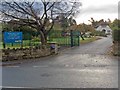
Recreational Gardens, Haygate Rd
Public conveniences, tennis courts and a bowling green are included in the amenities provided.
Image: © Mike White
Taken: 28 Oct 2008
0.15 miles
9
Union Street, Wellington
Viewed from Wrekin Road. The Wrekin Inn http://www.geograph.org.uk/photo/3705284 is on the right.
Image: © Jaggery
Taken: 10 Oct 2013
0.16 miles
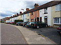
10

The Mount, Wellington
The central, redbrick part of this building is an early 19th century house. Its construction date is not recorded but it was Grade II listed https://britishlistedbuildings.co.uk/101033319-the-mount-wellington#.YvKVLnbMLIU & https://historicengland.org.uk/listing/the-list/list-entry/1033319 in 1983 and is now converted to flats and apartments.
Image: © Richard Law
Taken: 6 Aug 2022
0.17 miles