IMAGES TAKEN NEAR TO
Victoria Road, TELFORD, TF1 1LQ
Introduction
This page details the photographs taken nearby to Victoria Road, TF1 1LQ by members of the Geograph project.
The Geograph project started in 2005 with the aim of publishing, organising and preserving representative images for every square kilometre of Great Britain, Ireland and the Isle of Man.

There are currently over 7.5m images from over14,400 individuals and you can help contribute to the project by visiting https://www.geograph.org.uk
Image Map (Loading...)


Getting Data...Please wait
Leaflet Map data © OpenStreetMap
Images are licensed for reuse under creativecommons.org/licenses/by-sa/2.0
Notes
- Clicking on the map will re-center to the selected point.
- The higher the marker number, the further away the image location is from the centre of the postcode.
Image Listing (250 Images Found)
Images are licensed for reuse under creativecommons.org/licenses/by-sa/2.0
Image
Details
Distance
1
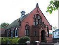
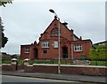
Wellington - former Primitive Methodist church
The former Primitive Methodist Chapel is now a Mosque. See http://www.wellingtonwalkersarewelcome.org.uk/images/wellington_walking_and_town_map_v21.pdf for more details.
Image: © Dave Bevis
Taken: 22 Sep 2012
0.06 miles
2
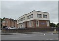
Telford Central Mosque, Wellington
Curiously named, as the mosque is near central Wellington, on the corner of Tan Bank and Victoria Road, several kilometres from central Telford. The building used to be a Primitive Methodist Chapel.
Image: © Jaggery
Taken: 10 Oct 2013
0.06 miles
3
Wellington: Telford Central Mosque
This brick and terracotta building was opened in 1898 as a Primitive Methodist Chapel. It closed in 1966. It is now a mosque operated by the Shropshire Islamic Foundation.
Image: © Jonathan Hutchins
Taken: 1 Jun 2016
0.06 miles
4
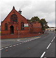
Citizens Advice Bureau, Wellington
The yellow Citizens Advice Bureau name sign is on the wall
of the building on the corner of Victoria Road and Tan Bank.
Image: © Jaggery
Taken: 10 Oct 2013
0.06 miles
5
Wellington: Citizens Advice Bureau
Image: © Jonathan Hutchins
Taken: 1 Jun 2016
0.07 miles
6
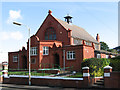
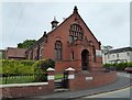
Wellington - former Primitive Methodist school
The former Primitive Methodist Sunday School is now a Pentecostal Church. See http://www.wellingtonwalkersarewelcome.org.uk/images/wellington_walking_and_town_map_v21.pdf for more details.
Image: © Dave Bevis
Taken: 22 Sep 2012
0.07 miles
7
Wellington: Bethel United Church of Jesus Christ (Apostolic)
This brick-and-terracotta building was originally a Primitive Methodist School and stands immediately adjacent to its corresponding church of 1898, now a mosque (see http://www.geograph.org.uk/photo/4978184 ).
Image: © Jonathan Hutchins
Taken: 1 Jun 2016
0.07 miles
8
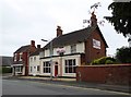
Wellington: Dhaka restaurant and Perry's Cycles
Image: © Jonathan Hutchins
Taken: 1 Jun 2016
0.09 miles
9
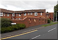
5 round holes in the wall, Roseway, Wellington
The holes are a design feature. Viewed from the Wrekin Road end of Roseway.
Image: © Jaggery
Taken: 10 Oct 2013
0.09 miles
10
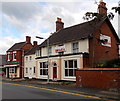
Dhaka, Wellington
Town centre Indian restaurant at 35 Tan Bank.
Image: © Jaggery
Taken: 10 Oct 2013
0.09 miles