IMAGES TAKEN NEAR TO
New Church Road, TELFORD, TF1 1JE
Introduction
This page details the photographs taken nearby to New Church Road, TF1 1JE by members of the Geograph project.
The Geograph project started in 2005 with the aim of publishing, organising and preserving representative images for every square kilometre of Great Britain, Ireland and the Isle of Man.

There are currently over 7.5m images from over14,400 individuals and you can help contribute to the project by visiting https://www.geograph.org.uk
Image Map
Images are licensed for reuse under creativecommons.org/licenses/by-sa/2.0
Notes
- Clicking on the map will re-center to the selected point.
- The higher the marker number, the further away the image location is from the centre of the postcode.
Image Listing (76 Images Found)
Images are licensed for reuse under creativecommons.org/licenses/by-sa/2.0
Image
Details
Distance
1
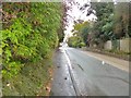
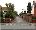
Wellington, Watling Street
Formerly A5, this section is now B5061, Holyhead Road, following the course of Roman Watling Street, from Hadrian's Wall to Dover.
Image: © Mike Faherty
Taken: 13 Oct 2014
0.06 miles
2
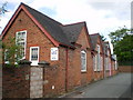
The Belfrey Arts Centre, Wellington
Converted from the old Prince's Street Primary School in 1971, this is now an arts centre for the people of Wellington and Arleston area. Their website is http://www.belfreytheatre.com/
Image: © Richard Law
Taken: 13 Jun 2009
0.06 miles
3
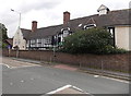
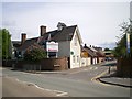
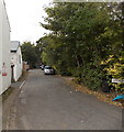
Worthington Mews, Wellington
Viewed across Holyhead Road. Now in residential use, the building used to be the Old Hall School, which relocated to Stanley Road.
Image: © Jaggery
Taken: 10 Oct 2013
0.07 miles
4
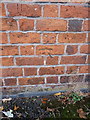
OS benchmark - Wellington, Belfrey Arts Centre
A rather poorly preserved OS cutmark on the front wall of Image; originally levelled at 111.517m above Ordnance Datum Newlyn.
Image: © Richard Law
Taken: 8 Dec 2013
0.07 miles
5
Prince's Street, Wellington
Viewed across Holyhead Road.
Image: © Jaggery
Taken: 10 Oct 2013
0.07 miles
6
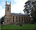
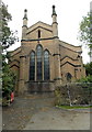
South side of Christ Church, Wellington
Anglican church in the Diocese of Lichfield, located between
Church Walk and Mill Bank to the east and New Church Road to the west.
Image: © Jaggery
Taken: 10 Oct 2013
0.08 miles
7
The former Old Hall School
This was formerly the premises of The Old Hall School which was founded in 1845, and said to be the oldest building in Wellington. The school moved out in 2006, and the buildings have been converted to apartments, which along with the new builds in the grounds, are now known as Worthington Mews. The whole building was Grade II listed https://britishlistedbuildings.co.uk/101352011-the-old-hall-preparatory-school-wellington#.XIz-tij7TIU in 1983.
Image: © Richard Law
Taken: 3 May 2009
0.08 miles
8
East side of Christ Church, Wellington
Viewed along Church Walk. The Anglican church is in the Diocese of Lichfield.
http://www.geograph.org.uk/photo/3703606 to a view of the south side.
Image: © Jaggery
Taken: 10 Oct 2013
0.08 miles
9
Church Walk, Wellington
Viewed from the Mill Bank end looking towards the east side http://www.geograph.org.uk/photo/3703631 of Christ Church.
Image: © Jaggery
Taken: 10 Oct 2013
0.08 miles
10
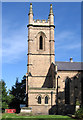
Wellington - Christ Church tower
Viewed from the graveyard to the south.
Image: © Dave Bevis
Taken: 22 Sep 2012
0.08 miles