IMAGES TAKEN NEAR TO
Roseway, TELFORD, TF1 1HU
Introduction
This page details the photographs taken nearby to Roseway, TF1 1HU by members of the Geograph project.
The Geograph project started in 2005 with the aim of publishing, organising and preserving representative images for every square kilometre of Great Britain, Ireland and the Isle of Man.

There are currently over 7.5m images from over14,400 individuals and you can help contribute to the project by visiting https://www.geograph.org.uk
Image Map
Images are licensed for reuse under creativecommons.org/licenses/by-sa/2.0
Notes
- Clicking on the map will re-center to the selected point.
- The higher the marker number, the further away the image location is from the centre of the postcode.
Image Listing (151 Images Found)
Images are licensed for reuse under creativecommons.org/licenses/by-sa/2.0
Image
Details
Distance
1
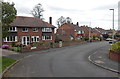
Rosthwaite, Wellington
Viewed from the Holyhead Road end of Rosthwaite looking north towards Roseway.
Image: © Jaggery
Taken: 10 Oct 2013
0.08 miles
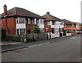
2

Row of shops at the northern end of New Church Road, Wellington
Nearest the camera is a Polish delicatessen named Delikatesy Oliwia.
Image: © Jaggery
Taken: 10 Oct 2013
0.10 miles
3
New Church Road houses, Wellington
Viewed from near the access road to the west side of Christ Church. http://www.geograph.org.uk/photo/3703606
Image: © Jaggery
Taken: 10 Oct 2013
0.10 miles
4
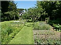
Part of the gardens of Sunnycroft, Wellington
These are in fact allotments utilised by local residents to grow their veg, soft fruit etc, which they tend and harvest accordingly. We spoke to a couple. I had thought that the National Trust must tend the gardens, but it is local people power that makes the gardens looks this good.
The house, Sunnycroft, was in fact self-sufficient in terms of garden produce, fruit, veg and also pork, beef etc. This is maybe something like how the gardens might have appeared in the heyday of Sunnycroft.
Image: © Jeremy Bolwell
Taken: 4 Jun 2023
0.12 miles
5
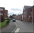
St John Street, Wellington
Looking south from the High Street end.
Image: © Jaggery
Taken: 10 Oct 2013
0.12 miles
6
Part of the Sunnycroft estate at Wellington
This building was a coach house and stables and accommodation for the coachman, and later a car garage. It incorporates two pigsties, and there are other pigsties nearby attached to the main house. Sunnycroft was established in 6-9 acres of land if I recall correctly, with fields for grazing horses, cattle and sheep. Plus several pigsty facilities for rearing different aged piggies.
Image: © Jeremy Bolwell
Taken: 4 Jun 2023
0.12 miles
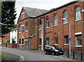
7
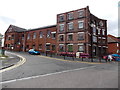
St John Street side of the former Chad Valley Wrekin Toy Works in Wellington
http://www.geograph.org.uk/photo/3702003 to a front view (High Street) and some details.
Image: © Jaggery
Taken: 10 Oct 2013
0.13 miles
8
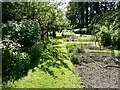
Part of the gardens at Sunnycroft, Wellington
Allotments in fact. Local residents tend their own patches. Most common veg and soft fruit can be seen here. A lovely space. Great to explore as you familiarise yourself with Sunnycroft.
Image: © Jeremy Bolwell
Taken: 4 Jun 2023
0.13 miles
9
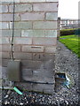
OS benchmark - Wellington, flats on High Street
A slightly shonky OS cutmark in the bricks of flats 34-48 High Street; originally levelled at 105.738m above Ordnance Datum Newlyn.
Image: © Richard Law
Taken: 8 Dec 2013
0.13 miles
10
Old Methodist Chapel
The old Methodist Chapel in St John Street, Wellington. Later incorporated into the Chad Valley Toy Factory. See Image]
Image: © Gordon Cragg
Taken: 7 Jul 2009
0.13 miles