1
Local bus to High Ercall
In the 1960s, local bus services in and around Wellington, Shropshire were provided either by Midland Red or by a variety of independent operators. One of the independents was Butter's, whose Leyland TS8 is seen here in Charlton Street, Wellington on a service to High Ercall - a longish run through the lanes.
Image: © Dr Neil Clifton
Taken: 31 Aug 1963
0.01 miles
2
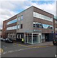
Wellington - dental surgery on Queen Street
Image: © Dave Bevis
Taken: 22 Sep 2012
0.04 miles
3
26 Vineyard Road, Wellington
Built in the late 18th century, and Grade II listed https://britishlistedbuildings.co.uk/101209967-26-vineyard-road-wellington#.XKzgoJhKjIU & https://historicengland.org.uk/listing/the-list/list-entry/1209967 in 1983; the ground floor windows are rather more recent.
Image: © Richard Law
Taken: 8 Apr 2019
0.04 miles
4
East along Vineyard Road in Wellington
Image: © Richard Law
Taken: 6 Aug 2022
0.04 miles
5
OS benchmark - Wellington, Vineyard Road
A rather poor example of the ilk, to be honest I'm not convinced this is the real thing, as the OS would rarely cut the datum line into the mortar of a brick wall. However, it's at the correct grid ref, and matches the description of a mark described in the OS database, so I have recorded it as such. Originally levelled in 1966 at 96.646m above Ordnance Datum Newlyn.
Image: © Richard Law
Taken: 5 Jul 2014
0.05 miles
6
The former offices of Severn Trent Water, Wellington
More properly known as 22 Vineyard Road, this late 18th century town house was Grade II listed https://britishlistedbuildings.co.uk/101033329-severn-trent-water-authority-wellington#.XKze15hKjIU & https://historicengland.org.uk/listing/the-list/list-entry/1033329 in 1983; the bay window and fancy columns around the porch are a later addition.
Image: © Richard Law
Taken: 8 Apr 2019
0.05 miles
7
Parville House, Wellington
A rather fine, 18th century (Georgian) town house, which attracted a Grade II listing https://britishlistedbuildings.co.uk/101292509-parville-house-wellington#.XKzccphKjIU & https://historicengland.org.uk/listing/the-list/list-entry/1292509 in 1983. Now converted to social housing.
Image: © Richard Law
Taken: 8 Apr 2019
0.05 miles
8
Wellington - Tyrone House
On Church Street.
Image: © Dave Bevis
Taken: 22 Sep 2012
0.08 miles
9
All Saint’s Church Wellington
Imposing 18th Century church in the centre of Wellington
Image: © Andrew Shannon
Taken: 14 Mar 2023
0.08 miles
10
Barclays Wellington
The modern boxlike design of the Barclays branch on the corner of Church Street and Queen Street contrasts with the classical look http://www.geograph.org.uk/photo/3694800 of the nearby NatWest branch.
Image: © Jaggery
Taken: 10 Oct 2013
0.08 miles


