IMAGES TAKEN NEAR TO
The Row, SHIFNAL, TF11 9LJ
Introduction
This page details the photographs taken nearby to The Row, TF11 9LJ by members of the Geograph project.
The Geograph project started in 2005 with the aim of publishing, organising and preserving representative images for every square kilometre of Great Britain, Ireland and the Isle of Man.

There are currently over 7.5m images from over14,400 individuals and you can help contribute to the project by visiting https://www.geograph.org.uk
Image Map
Images are licensed for reuse under creativecommons.org/licenses/by-sa/2.0
Notes
- Clicking on the map will re-center to the selected point.
- The higher the marker number, the further away the image location is from the centre of the postcode.
Image Listing (27 Images Found)
Images are licensed for reuse under creativecommons.org/licenses/by-sa/2.0
Image
Details
Distance
2
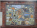
Mural at Kemberton Village Hall
This plaque was produced by many of the people who lived in Kemberton in 2000 to mark the Millennium. It can be seen on the wall of the village hall.
Image: © A Holmes
Taken: 12 Apr 2007
0.02 miles
3
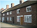
Miners' cottages at Kemberton
These cottages show every sign of being mineworkers' homes, especially the huge chimneys which vented several fireplaces. Until about 40 years ago, there was a colliery at Kemberton, although strictly speaking, it was in the area now occupied by Halesfield Industrial Estate, roughly at SJ712055, which probably explains the existence of the public footpath leading WNW-wards from the village.
This area lies towards the viable edge of the East Shropshire coalfield http://shropshiremines.org.uk/misc/shropmine/coalbrookdale_coalfield.htm The pit closed in 1967.
Image: © Richard Law
Taken: 18 Dec 2009
0.02 miles
4
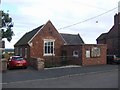
Kemberton Village Hall
A ceramic mural Image features designs by the village children.
Kemberton was once an industrial centre like other villages with water power near the Ironbridge Gorge. The village had blast furnaces, nail makers and a colliery.
Image: © John M
Taken: 29 Aug 2009
0.02 miles
6
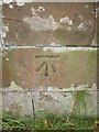
Ordnance Survey Cut Mark
This OS cut mark can be found on the south face of St John's Church. It marks a point 108.289m above mean sea level.
Image: © Adrian Dust
Taken: 1 Oct 2016
0.05 miles
7
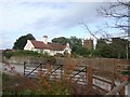
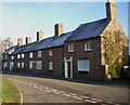
Church Farm
The houses and farms surrounding the church have private gates into the churchyard.
Image: © John M
Taken: 29 Aug 2009
0.05 miles
8
Cut benchmark on St Andrew's Church
OS benchmark on the SE buttress of the church in Kemberton; originally levelled at 108.289m above Ordnance Datum Newlyn.
Image: © Richard Law
Taken: 14 Jul 2013
0.06 miles
9
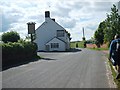
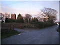
Hall Lane
Walking West out of Kemberton.
Image: © Gordon Griffiths
Taken: 14 May 2007
0.06 miles
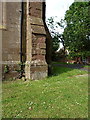
10
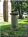
Monument to John Cherrington, Kemberton
A rather unusual cylindrical sandstone monument/tomb for John Cherrington of the village, who died in 1817, and which was Grade II listed https://britishlistedbuildings.co.uk/101273841-monument-to-john-cherrington-about-5-metres-west-of-the-tower-of-the-church-of-st-andrew-kemberton#.Xp8UnMhKjcs & https://historicengland.org.uk/listing/the-list/list-entry/1273841 in 1984.
Image: © Richard Law
Taken: 20 Apr 2020
0.06 miles