IMAGES TAKEN NEAR TO
Grindle, SHIFNAL, TF11 9JR
Introduction
This page details the photographs taken nearby to TF11 9JR by members of the Geograph project.
The Geograph project started in 2005 with the aim of publishing, organising and preserving representative images for every square kilometre of Great Britain, Ireland and the Isle of Man.

There are currently over 7.5m images from over14,400 individuals and you can help contribute to the project by visiting https://www.geograph.org.uk
Image Map (Loading...)


Getting Data...Please wait
Leaflet Map data © OpenStreetMap
Images are licensed for reuse under creativecommons.org/licenses/by-sa/2.0
Notes
- Clicking on the map will re-center to the selected point.
- The higher the marker number, the further away the image location is from the centre of the postcode.
Image Listing (17 Images Found)
Images are licensed for reuse under creativecommons.org/licenses/by-sa/2.0
Image
Details
Distance
1
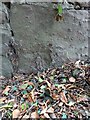
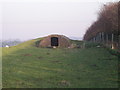
OS benchmark - Grindle House roadside wall
An OS cutmark (very weathered, granted) on the sandstone base course of a wall just east of the entrance to Grindle House. It was last verified by the OS in 1961 at 77.587m above Ordnance Datum Newlyn, but is actually much older than that, being marked on the 1881/82 map at 255.2 feet above (Liverpool) datum. The last few times I've passed this way and looked for it, it's been obscured by vegetation or below effective ground level, so finding it today was a pleasant surprise.
Image: © Richard Law
Taken: 18 Sep 2021
0.06 miles
8
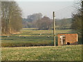
Pump house & a look down the Worfe valley
Irrigation pump house & a view down the Worfe valley.
Image: © Row17
Taken: 18 Feb 2008
0.18 miles
9
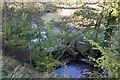
Sluice on Wesley Brook
This is just below Grindleforge Bridge.
Image: © Mike White
Taken: 20 Oct 2010
0.20 miles
10
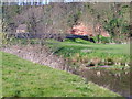
Wesley Brook at Grindleforge
Wesley Brook joins the River Worfe at Ryton to the south. The land around Grindleforge is managed under Environmental Stewardship as permanent pasture and receives no artificial fertilizer. There is abundant wildlife found in this area.
Image: © A Holmes
Taken: 7 Apr 2007
0.21 miles