IMAGES TAKEN NEAR TO
Stafford Place, SHIFNAL, TF11 9BH
Introduction
This page details the photographs taken nearby to Stafford Place, TF11 9BH by members of the Geograph project.
The Geograph project started in 2005 with the aim of publishing, organising and preserving representative images for every square kilometre of Great Britain, Ireland and the Isle of Man.

There are currently over 7.5m images from over14,400 individuals and you can help contribute to the project by visiting https://www.geograph.org.uk
Image Map (Loading...)


Getting Data...Please wait
Leaflet Map data © OpenStreetMap
Images are licensed for reuse under creativecommons.org/licenses/by-sa/2.0
Notes
- Clicking on the map will re-center to the selected point.
- The higher the marker number, the further away the image location is from the centre of the postcode.
Image Listing (308 Images Found)
Images are licensed for reuse under creativecommons.org/licenses/by-sa/2.0
Image
Details
Distance
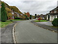
1
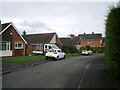
Bungalows north of the main part of Silvermere Park estate
A small 'loop road' off the main route; most of the estate was built in the late 1960s or thereabouts, although a few properties have been added or redeveloped in the meantime.
Image: © Richard Law
Taken: 29 Oct 2021
0.03 miles
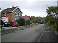
2
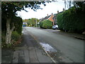
East along Silvermere Park
This 1960s housing development is named after the narrow lake which lies just behind the gardens of the houses on the right. It's marked on the map of 1901/1902 as 'fishpond' but is nowadays little more than a shallow pool, much reduced in size and length.
Image: © Richard Law
Taken: 29 Oct 2021
0.04 miles
3
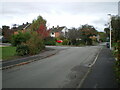
Looking along Silvermere Park
This 1960s housing development is named after the narrow lake which lies just behind the gardens of the houses offshot to the right. It's marked on the map of 1901/1902 as 'fishpond' but is nowadays little more than a shallow pool, much reduced in size.
Image: © Richard Law
Taken: 29 Oct 2021
0.05 miles
4
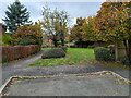
Small green space behind houses on Meadway
The dropped kerb rather suggests that this small plot may once have been earmarked for a house, but it's never happened yet in 30-odd years. I suspect the surrounding residents look after the trees, grass and shrubs.
Image: © Richard Law
Taken: 13 Nov 2021
0.05 miles
6
Houses on Meadway
1970s/1980s housing on the Meadway part of Silvermere Park estate. It's a very quiet part of town, aside from the occasional rumble of a train on the embankment in the trees behind the houses on the left.
Image: © Richard Law
Taken: 13 Nov 2021
0.08 miles
7
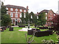
The Idsall Rooms building, part of the Park House hotel
Until fairly recently this fine building was Image, but has lost that name now, although it's still operated as part of the adjoining Image The main part on the left dates from 1699, with the other buildings being added in the 18th and mid 19th century. The whole was Grade II* listed https://britishlistedbuildings.co.uk/101053637-the-idsall-rooms-park-house-hotel-shifnal#.XxW1655Kjcs & https://historicengland.org.uk/listing/the-list/list-entry/1053637 in 1984.
Image: © Richard Law
Taken: 20 Jul 2020
0.09 miles
8
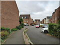
Houses at the eastern end of The Grove
The houses and flats here were built around 2000 on the site of the one-time squash club and swimming pool; although it was a private club, the membership was very reasonably priced, and sadly the well-used facilities have never really been replaced in the town since.
Image: © Richard Law
Taken: 13 Nov 2021
0.10 miles
9
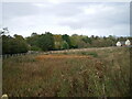
Another drainage pond
A second attenuation pond area, built in addition to the one just to the NE Image, which stores runoff from new housing nearby.
Image: © Richard Law
Taken: 29 Oct 2021
0.10 miles
10
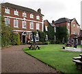
Butlers Bar & Restaurant, Park House Hotel, Shifnal
Set back from the east side of Park Street.
A nearby blue plaque records that this is Idsall House, dating from 1699.
Image: © Jaggery
Taken: 26 Nov 2015
0.10 miles