IMAGES TAKEN NEAR TO
Murphys Lane, SHIFNAL, TF11 8QP
Introduction
This page details the photographs taken nearby to TF11 8QP by members of the Geograph project.
The Geograph project started in 2005 with the aim of publishing, organising and preserving representative images for every square kilometre of Great Britain, Ireland and the Isle of Man.

There are currently over 7.5m images from over14,400 individuals and you can help contribute to the project by visiting https://www.geograph.org.uk
Image Map (Loading...)


Getting Data...Please wait
Leaflet Map data © OpenStreetMap
Images are licensed for reuse under creativecommons.org/licenses/by-sa/2.0
Notes
- Clicking on the map will re-center to the selected point.
- The higher the marker number, the further away the image location is from the centre of the postcode.
Image Listing (19 Images Found)
Images are licensed for reuse under creativecommons.org/licenses/by-sa/2.0
Image
Details
Distance
1
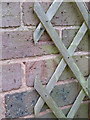
OS benchmark - no 4 Nanny Murphy's Lane
An OS cutmark in the brickwork of house no 4 on the lane, originally levelled at 124.52m above Ordnance Datum Newlyn.
Image: © Richard Law
Taken: 9 Nov 2013
0.03 miles
2
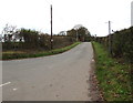
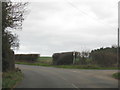
At the corner of Nanny Murphy's Lane
The best explanation for the origin of the name Nanny Murphy's Lane, comes from http://www.highbeam.com/doc/1G1-60490880.html which refers to a local lady called Mary Yates (1649 - 1776) who lived at Lizard Common just up the road from here in the mid 17th century. Amongst her achievements were to walk to London shortly after the Great Fire of 1666, to get married for the 3rd time in her 90s, and to live to the ripe old age of 127. Quite how much of this is genuinely true is rather hard to establish now.
That's postbox number TF11 144 at the junction.
Image: © Richard Law
Taken: 10 Aug 2008
0.09 miles
3
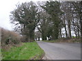
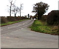
Western end of Nanny Murphy's Lane near Shifnal
Looking ENE along Nanny Murphy's Lane from the corner of the B4379 north of Shifnal.
Image: © Jaggery
Taken: 16 Nov 2015
0.11 miles
4
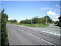
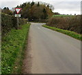
Towards Crackleybank and Watling Street from Shifnal
NNE of the Nanny Murphy's Lane junction north of Shifnal, the B4379 heads towards
Crackleybank and an arrow-straight part of the A5 Watling Street, both out of shot.
Image: © Jaggery
Taken: 16 Nov 2015
0.11 miles
6
Broken Give Way sign on a corner near Shifnal
In mid-November 2015, the triangular sign is on the grass below its post on a bank on the corner of Nanny Murphy's Lane and the B4379. Its demise has taken some time, based on the evidence of a May 2011 Google Earth Street View when the sign was on the post, but facing the hedge not Nanny Murphy's Lane.
Presumably one or more vehicle collisions over the years loosened the screws securing the sign to the post.
Image: © Jaggery
Taken: 16 Nov 2015
0.13 miles
7
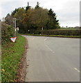
Western end of Nanny Murphy's Lane near Shifnal
The Give Way sign is on the approach to the B4379 junction north of Shifnal.
Image: © Jaggery
Taken: 16 Nov 2015
0.14 miles
8
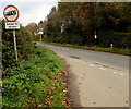
Two signs on a corner near Shifnal
On the corner of Nanny Murphy's Lane and the B4379. In the UK, warning signs are triangular and red-edged. The one in the background warns of no footpath for half a mile. Red-edged circular signs indicate a prohibition such as No Cycling, No Motor Vehicles or, as here, no vehicles heavier than the weight shown.
Image: © Jaggery
Taken: 16 Nov 2015
0.15 miles
9
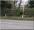
Gas pipeline marker post north of Shifnal
Near the Nanny Murphy's Lane junction, the white post marks the location of a gas pipeline under the B4379. Small yellow notices tell contractors what to do before beginning any work in or on the road surface hereabouts.
Image: © Jaggery
Taken: 16 Nov 2015
0.15 miles