IMAGES TAKEN NEAR TO
Wheatfield Drive, SHIFNAL, TF11 8HL
Introduction
This page details the photographs taken nearby to Wheatfield Drive, TF11 8HL by members of the Geograph project.
The Geograph project started in 2005 with the aim of publishing, organising and preserving representative images for every square kilometre of Great Britain, Ireland and the Isle of Man.

There are currently over 7.5m images from over14,400 individuals and you can help contribute to the project by visiting https://www.geograph.org.uk
Image Map (Loading...)


Getting Data...Please wait
Leaflet Map data © OpenStreetMap
Images are licensed for reuse under creativecommons.org/licenses/by-sa/2.0
Notes
- Clicking on the map will re-center to the selected point.
- The higher the marker number, the further away the image location is from the centre of the postcode.
Image Listing (92 Images Found)
Images are licensed for reuse under creativecommons.org/licenses/by-sa/2.0
Image
Details
Distance
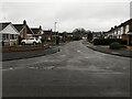
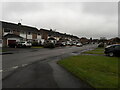
1
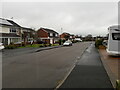
Houses on Wheatfield Drive
Part of the extensive housing estate looped by Beech Drive and Wheatfield Drive, all built in the late '60s or early '70s.
Image: © Richard Law
Taken: 14 Jan 2021
0.03 miles
2
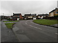
Houses at the junction of Wheatfield Drive and Brookside Close
Image: © Richard Law
Taken: 14 Jan 2021
0.06 miles
3
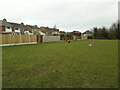
Northern corner of the recreation field
Wheatfield Drive recreation field is a large, often rather damp, open field between Wheatfield Drive and Haughton Road. A football pitch is marked out at times, and there are swings, slides, roundabouts etc at the other end. Plus a stream, which is normally of great interest to the two dogs here.
Image: © Richard Law
Taken: 15 Feb 2021
0.06 miles
4
Houses on Oakfield Road
Together with Sycamore Close, Beech Drive and Wheatfield Drive, the name of this road reflects the once-rural nature of the area. That came to an end in the late '60s or early '70s when the large housing estate was built.
Image: © Richard Law
Taken: 14 Jan 2021
0.07 miles
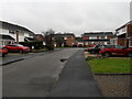
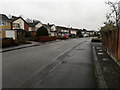
5
Houses on Brookside Close
Bungalows on the north side of the road, and two-storey houses on the south - all date from the time that this whole estate was built in the late '60s or early '70s.
Image: © Richard Law
Taken: 14 Jan 2021
0.07 miles
6
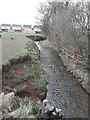
Wesley Brook on the north side of Shifnal
The brook here runs alongside a rather damp recreation field, and is much enjoyed by kids and dogs.
Image: © Richard Law
Taken: 15 Feb 2021
0.07 miles
8
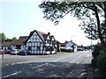
White Hart and Beehive Shifnal
White Hart - Shifnal's real beer mecca. Beehive sports the old Bass emblems.
Image: © al partington
Taken: 12 Jul 2006
0.08 miles
9
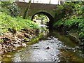
Wesley Brook disappears from public sight
The arched bridge gives access to a private house and the Wesley brook here passes from the public domain into the private. Another bridge is visible through the arch.
Image: © Mike White
Taken: 12 Apr 2009
0.10 miles
10
Houses on Beech Drive
A large estate of late '60s or early '70s housing; the small museum in Shifnal has a photo of the developers removing a large beech tree in the area, which may well have been the inspiration for the street name.
Image: © Richard Law
Taken: 14 Jan 2021
0.11 miles