IMAGES TAKEN NEAR TO
Haughton Lane, SHIFNAL, TF11 8HE
Introduction
This page details the photographs taken nearby to Haughton Lane, TF11 8HE by members of the Geograph project.
The Geograph project started in 2005 with the aim of publishing, organising and preserving representative images for every square kilometre of Great Britain, Ireland and the Isle of Man.

There are currently over 7.5m images from over14,400 individuals and you can help contribute to the project by visiting https://www.geograph.org.uk
Image Map
Images are licensed for reuse under creativecommons.org/licenses/by-sa/2.0
Notes
- Clicking on the map will re-center to the selected point.
- The higher the marker number, the further away the image location is from the centre of the postcode.
Image Listing (170 Images Found)
Images are licensed for reuse under creativecommons.org/licenses/by-sa/2.0
Image
Details
Distance
1
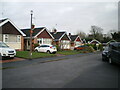
Houses around The Paddock
A small development, probably 1970s, of bungalows around a cul de sac.
Image: © Richard Law
Taken: 24 Dec 2020
0.04 miles
2
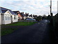
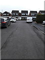
Bungalows on Haughton Drive
Tucked away on a private (unadopted) road off Haughton Lane
Image: © Richard Law
Taken: 24 Dec 2020
0.04 miles
3
Parkland west of Haughton Lane
Open fields with a scattering of large trees (we used to call them the 'Tunnel Trees' as kids, as it was possible to crawl around in the lower branches following a series of narrow tunnels)
Image: © Richard Law
Taken: 24 Dec 2020
0.06 miles
4
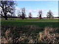
The 'Tunnel Trees' off Haughton Lane
Long known as the Tunnel Trees in our family, as we were able to crawl around within those tight-growing lower branches as kids. We must have ended up filthy dirty.
Image: © Richard Law
Taken: 24 Dec 2020
0.07 miles
5
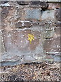
OS benchmark - Haughton Lane
A cut mark in the wall, 3m north of the junction with Priorslee Road (at the 5-ways roundabout). Levelled to a height of 90.13m, or 295'8" above Ordnance Datum Newlyn. The yellow lichen slightly obscures the mark, but it seems churlish to wire-brush it off.
Image: © Richard Law
Taken: 28 Jul 2013
0.08 miles
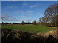
6
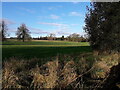
Field west of Haughton Lane
Looking across an open field in the general direction of Image, the Grade II* listed property not really being visible from this angle as it's hidden by the trees.
Image: © Richard Law
Taken: 24 Dec 2020
0.08 miles
7
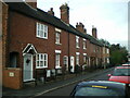
Cottages on Shrewsbury Fields
19th century cottages in a terrace on the west side of the narrow Shrewsbury Fields.
Image: © Richard Law
Taken: 22 Dec 2020
0.08 miles
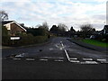
8
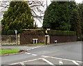
Junction of Haughton Lane and Shrewsbury Road, Shifnal
Haughton Lane on the left leads to Haughton Bridge and Haughton Village Farm.
The B4379 Shrewsbury Road on the right leads to the town centre.
Image: © Jaggery
Taken: 26 Nov 2015
0.09 miles
9
Bungalows on Shrewsbury Fields
Built around the 1970s, these bungalows and some houses behind the photographer position form the end of Shrewsbury Fields.
Image: © Richard Law
Taken: 22 Dec 2020
0.09 miles
10
Houses on the corner at the southern end of Maple Close
Image: © Richard Law
Taken: 17 Jan 2021
0.09 miles