IMAGES TAKEN NEAR TO
Limekiln Lane, NEWPORT, TF10 9EY
Introduction
This page details the photographs taken nearby to Limekiln Lane, TF10 9EY by members of the Geograph project.
The Geograph project started in 2005 with the aim of publishing, organising and preserving representative images for every square kilometre of Great Britain, Ireland and the Isle of Man.

There are currently over 7.5m images from over14,400 individuals and you can help contribute to the project by visiting https://www.geograph.org.uk
Image Map
Images are licensed for reuse under creativecommons.org/licenses/by-sa/2.0
Notes
- Clicking on the map will re-center to the selected point.
- The higher the marker number, the further away the image location is from the centre of the postcode.
Image Listing (15 Images Found)
Images are licensed for reuse under creativecommons.org/licenses/by-sa/2.0
Image
Details
Distance
3
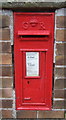
George V postbox on Limekiln Lane Lilleshall
Postbox No. TF10 234.
Image: © JThomas
Taken: 10 Aug 2019
0.03 miles
4
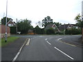
Bend on Limekiln Lane, Lilleshall
Junction with Willmoor Lane.
Image: © JThomas
Taken: 10 Aug 2019
0.06 miles

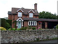
6
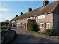
Stone cottages, Lilleshall
A terrace of stone cottages just off Limekiln Lane.
Image: © Richard Law
Taken: 15 Jan 2012
0.15 miles

8
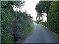
The bottom of the path from the hill
Emerging onto the road around the north side of Lilleshall Hill on a cold but bright January day.
Image: © Richard Law
Taken: 15 Jan 2012
0.17 miles
9

Remains of the Donnington Wood canal at Lilleshall
Very little remains of the canal itself, apart from a boggy ditch through this area. The canal originally served to connect coal pits at Donnington Wood to the road network near Pave Lane. It opened in 1767, and closed eventually in 1904, since when much of the visible course of the waterway has been lost to dereliction and neglect.
http://en.wikipedia.org/wiki/Donnington_Wood_Canal
Image: © Richard Law
Taken: 15 Jan 2012
0.17 miles
10

Ready for the next crop
Lilleshall (Sutherland) Memorial is on the hilltop.
Image: © Row17
Taken: 4 Jun 2008
0.18 miles