IMAGES TAKEN NEAR TO
Moreton, NEWPORT, TF10 9DX
Introduction
This page details the photographs taken nearby to TF10 9DX by members of the Geograph project.
The Geograph project started in 2005 with the aim of publishing, organising and preserving representative images for every square kilometre of Great Britain, Ireland and the Isle of Man.

There are currently over 7.5m images from over14,400 individuals and you can help contribute to the project by visiting https://www.geograph.org.uk
Image Map
Images are licensed for reuse under creativecommons.org/licenses/by-sa/2.0
Notes
- Clicking on the map will re-center to the selected point.
- The higher the marker number, the further away the image location is from the centre of the postcode.
Image Listing (4 Images Found)
Images are licensed for reuse under creativecommons.org/licenses/by-sa/2.0
Image
Details
Distance
1
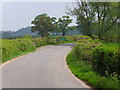
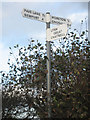
County Boundary
Going from Shropshire into Staffordshire
Image: © A Holmes
Taken: 3 May 2007
0.13 miles
2
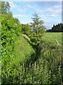
The Moreton Brook
Well overgrown after several weeks with very little rain; compare this with its normal may-time condition in Image
Image: © Richard Law
Taken: 11 Jun 2011
0.16 miles
3
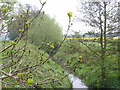
Back Brook
A quiet little brook with ducks dabbling (until I disturbed them!)
Image: © A Holmes
Taken: 3 May 2007
0.21 miles