IMAGES TAKEN NEAR TO
Pitchcroft Lane, NEWPORT, TF10 9AQ
Introduction
This page details the photographs taken nearby to Pitchcroft Lane, TF10 9AQ by members of the Geograph project.
The Geograph project started in 2005 with the aim of publishing, organising and preserving representative images for every square kilometre of Great Britain, Ireland and the Isle of Man.

There are currently over 7.5m images from over14,400 individuals and you can help contribute to the project by visiting https://www.geograph.org.uk
Image Map (Loading...)


Getting Data...Please wait
Leaflet Map data © OpenStreetMap
Images are licensed for reuse under creativecommons.org/licenses/by-sa/2.0
Notes
- Clicking on the map will re-center to the selected point.
- The higher the marker number, the further away the image location is from the centre of the postcode.
Image Listing (12 Images Found)
Images are licensed for reuse under creativecommons.org/licenses/by-sa/2.0
Image
Details
Distance
1
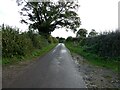
Walker on a lane
This chap is walking his dog, a Labrador I think.
Image: © Jeremy Bolwell
Taken: 1 Nov 2023
0.12 miles
3
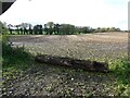
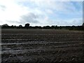
An old maize field beside the lane
Blocked off with a tree trunk.
Image: © Jeremy Bolwell
Taken: 1 Nov 2023
0.14 miles
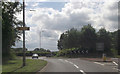
5
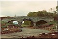
Pitchcroft railway bridge
This was taken on a date lost in the mists of my memory, but it was obviously as the A518 was being realigned along the old LNWR Wellington to Stafford railway line near Newport in Shropshire. My best guess would be 1993, I seemed to be pretty active with my camera around that time. The bridge is now gone and what the area now looks like can be seen in Row17's photograph at http://www.geograph.org.uk/photo/832556, which was taken looking across my photograph, left to right.
Image: © John Winder
Taken: Unknown
0.15 miles
6
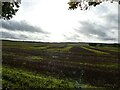
Looking over an old maize field
Autumnal scene. Summer seems a long time ago. Winter very near.
Image: © Jeremy Bolwell
Taken: 1 Nov 2023
0.17 miles
7
Wide open fields near Lilleshall
Almost like downland except for the cultivated element.
Image: © Jeremy Bolwell
Taken: 1 Nov 2023
0.19 miles
8
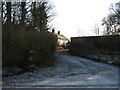
The Cottage
A Stone Cottage situated between the old and the new road, near to the Last Inn.
Image: © Paul Beaman
Taken: 13 Dec 2007
0.20 miles
9
The 'old' A518 main road
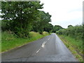
Now downgraded to a yellow road, since the realignment of the main drag in the 1990s.
Image: © Richard Law
Taken: 19 Aug 2012
0.21 miles
10
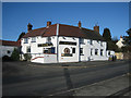
The Last Inn
The Last Inn on the edge of Church Aston, south of Newport
Image: © Anne Pollitt
Taken: 28 Nov 2006
0.23 miles