IMAGES TAKEN NEAR TO
Adeney, NEWPORT, TF10 8LY
Introduction
This page details the photographs taken nearby to TF10 8LY by members of the Geograph project.
The Geograph project started in 2005 with the aim of publishing, organising and preserving representative images for every square kilometre of Great Britain, Ireland and the Isle of Man.

There are currently over 7.5m images from over14,400 individuals and you can help contribute to the project by visiting https://www.geograph.org.uk
Image Map (Loading...)


Getting Data...Please wait
Leaflet Map data © OpenStreetMap
Images are licensed for reuse under creativecommons.org/licenses/by-sa/2.0
Notes
- Clicking on the map will re-center to the selected point.
- The higher the marker number, the further away the image location is from the centre of the postcode.
Image Listing (5 Images Found)
Images are licensed for reuse under creativecommons.org/licenses/by-sa/2.0
Image
Details
Distance
2
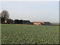
Farm
Farm buildings and barn conversions at Adanay.
Image: © Paul Beaman
Taken: 25 Jan 2007
0.08 miles
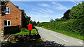
5
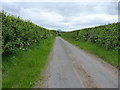
Along the track to Kynnersley Moor
Essentially a farm track, but also a bridleway, which leads across flat farmland toward Kynnersley. This end of it is metalled, but that soon comes to an end.
Image: © Richard Law
Taken: 17 May 2015
0.23 miles