IMAGES TAKEN NEAR TO
Longford, NEWPORT, TF10 8LN
Introduction
This page details the photographs taken nearby to TF10 8LN by members of the Geograph project.
The Geograph project started in 2005 with the aim of publishing, organising and preserving representative images for every square kilometre of Great Britain, Ireland and the Isle of Man.

There are currently over 7.5m images from over14,400 individuals and you can help contribute to the project by visiting https://www.geograph.org.uk
Image Map
Images are licensed for reuse under creativecommons.org/licenses/by-sa/2.0
Notes
- Clicking on the map will re-center to the selected point.
- The higher the marker number, the further away the image location is from the centre of the postcode.
Image Listing (4 Images Found)
Images are licensed for reuse under creativecommons.org/licenses/by-sa/2.0
Image
Details
Distance
1
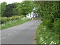
Cottages on the Bend.
Cottages on the Lilleshall to Edgmond road.
Image: © Paul Beaman
Taken: 6 May 2007
0.03 miles
2
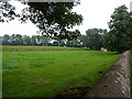
Roadside wall and field near Red Gables cottage
Image: © Richard Law
Taken: 19 Aug 2012
0.06 miles
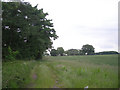
4
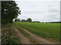
Farmland Track.
Farmland, looking towards Aston Hill.
Image: © Paul Beaman
Taken: 6 May 2007
0.20 miles