IMAGES TAKEN NEAR TO
Marsh Road, NEWPORT, TF10 8ER
Introduction
This page details the photographs taken nearby to Marsh Road, TF10 8ER by members of the Geograph project.
The Geograph project started in 2005 with the aim of publishing, organising and preserving representative images for every square kilometre of Great Britain, Ireland and the Isle of Man.

There are currently over 7.5m images from over14,400 individuals and you can help contribute to the project by visiting https://www.geograph.org.uk
Image Map (Loading...)


Getting Data...Please wait
Leaflet Map data © OpenStreetMap
Images are licensed for reuse under creativecommons.org/licenses/by-sa/2.0
Notes
- Clicking on the map will re-center to the selected point.
- The higher the marker number, the further away the image location is from the centre of the postcode.
Image Listing (7 Images Found)
Images are licensed for reuse under creativecommons.org/licenses/by-sa/2.0
Image
Details
Distance
2
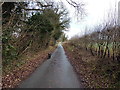
Byway near Chetwynd Grange
This metalled road is marked as a byway, but is in reality a dead-end drive to the two cottages at its western end, as it peters out into a footpath not far behind the camera position here.
Image: © Richard Law
Taken: 28 Jan 2017
0.09 miles
3

Lake in Caynton Gorse
The lake appears to be within the grounds of one of the houses at the far end; an island is accessed by a bridge, and they keep a small boat on the bank there.
Image: © Richard Law
Taken: 28 Jan 2017
0.10 miles
4
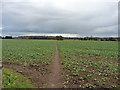
Footpath heading for Caynton Gorse
Daft Dog liked this - pheasants! The track peters out to a footpath near the woods, and then passes Sidlington Cottage and Cefn House, which are well fenced off from view.
Image: © Richard Law
Taken: 28 Jan 2017
0.20 miles
5
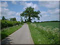
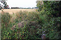
Lane and farmland near Edgmond
Low lying farmland that used to be marsh, hence the name Edgmond Marsh on some maps.
Image: © Bill Rowley
Taken: 31 May 2002
0.23 miles
6
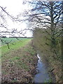
Black Brook, Edgmond
The brook presumably gets its name as it drains the rather peaty Edgmond Marsh to the NE of here, before joining the Pipe Strine brook on its way to the Tern near Crudgington.
Image: © Richard Law
Taken: 28 Jan 2017
0.24 miles