IMAGES TAKEN NEAR TO
Pickstock, NEWPORT, TF10 8AH
Introduction
This page details the photographs taken nearby to TF10 8AH by members of the Geograph project.
The Geograph project started in 2005 with the aim of publishing, organising and preserving representative images for every square kilometre of Great Britain, Ireland and the Isle of Man.

There are currently over 7.5m images from over14,400 individuals and you can help contribute to the project by visiting https://www.geograph.org.uk
Image Map
Images are licensed for reuse under creativecommons.org/licenses/by-sa/2.0
Notes
- Clicking on the map will re-center to the selected point.
- The higher the marker number, the further away the image location is from the centre of the postcode.
Image Listing (12 Images Found)
Images are licensed for reuse under creativecommons.org/licenses/by-sa/2.0
Image
Details
Distance
3
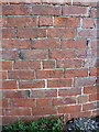
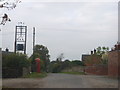
OS benchmark - Pickstock Manor
An OS cutmark on the wall of a building facing onto the road; originally levelled at 76.69m above Ordnance Datum Newlyn.
Image: © Richard Law
Taken: 22 Nov 2014
0.04 miles
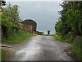
6
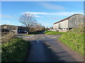
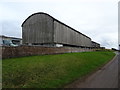
Pickstock Manor Farm
The farm appears to have diversified somewhat; the nearest barn stores caravans, whilst some of the further buildings are used for car servicing and MOT testing.
Image: © Richard Law
Taken: 22 Nov 2014
0.07 miles
10
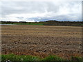
Stubble field, Pickstock
Towards the River Meese.
Image: © JThomas
Taken: 14 Mar 2020
0.18 miles