
IMAGES TAKEN NEAR TO
Beaumaris Road, NEWPORT, TF10 7BN
Introduction
This page details the photographs taken nearby to Beaumaris Road, TF10 7BN by members of the Geograph project.
The Geograph project started in 2005 with the aim of publishing, organising and preserving representative images for every square kilometre of Great Britain, Ireland and the Isle of Man.

There are currently over 7.5m images from over14,400 individuals and you can help contribute to the project by visiting https://www.geograph.org.uk
Image Map
Images are licensed for reuse under creativecommons.org/licenses/by-sa/2.0
Notes
- Clicking on the map will re-center to the selected point.
- The higher the marker number, the further away the image location is from the centre of the postcode.
Image Listing (197 Images Found)
Images are licensed for reuse under creativecommons.org/licenses/by-sa/2.0
Image
Details
Distance
1
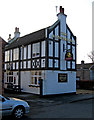
The Honeysuckle, 26 Beaumaris Road
A traditional pub tucked away in the town's back streets. It has a pool table, and a beer garden.
Another view:- Image
Image: © P L Chadwick
Taken: 6 Feb 2010
0.01 miles
2
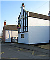
The Honeysuckle, 26 Beaumaris Road
Another view of this traditional pub:- Image
Image: © P L Chadwick
Taken: 6 Feb 2010
0.01 miles
3
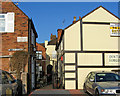
Part of back of 2c & 2b New Street
The building on the left has a sign saying "The Coachmans House 2C New Street". Underneath it is another sign saying "Pigfold". In a directory of 1828 there is a tavern or public house called "Pig Fold" in the High Street. So it seems very likely that this is the back of it. On the right is the back of 2b New Street "Britannia House". Again this may have been an inn or pub long ago, and the archway is especially intriguing. It could have led to a passage to the High Street for bringing horses through, but it has to be said this is pure speculation!
Image
Image: © P L Chadwick
Taken: 6 Feb 2010
0.07 miles
4
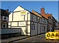
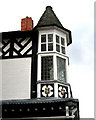
Back of Britannia House, 2b New Street
An old building which may be a survivor of the 1665 fire, which destroyed most of the town. Possibly was an inn or pub at one point.
Image
Image
Image: © P L Chadwick
Taken: 6 Feb 2010
0.07 miles
6
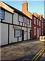
Britannia House Dental Practice, Britannia House, 2b New Street
Britannia House Dental Practice occupies part of the building known as Britannia House in New Street. The building, from the outside, appears to be very old. Possibly it was one of the few which survived the fire of 1665. Maybe there was once an inn here called the Britannia, which gave rise to the current name? Around the back of the building, and visible from the adjacent public car park, is an arch, which might at one time have had access to the High Street. Possibly there were stables at the back and this arch was part of a passage used to bring horses through.
Image
Image
Image: © P L Chadwick
Taken: 6 Feb 2010
0.08 miles
7
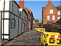
New Street
Not a lot of buildings remain in New Street. This is the oldest and probably most interesting bit. It was closed to traffic on the day the photograph was taken. The Parish Church can be glimpsed in the distance.
Image
Image: © P L Chadwick
Taken: 6 Feb 2010
0.08 miles
8
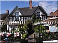
Smallwood Lodge
17th century timber framed house in the centre of Newport, one of the very few buildings to survive the great fire of Newport in 1665. Now a coffee shop, renowned for its indulgent cakes.
Image: © Oliver Dixon
Taken: 17 Jun 2010
0.08 miles

10
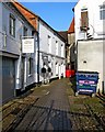
Passageway by Barclays Bank, 59 High Street
Number 59 High Street didn't become a bank until 1905, and later it became part of Barclays Bank. During the period of around 1690 to 1836, it was an inn or pub known as The Red Lion. Afterwards it was used for shops until it became bank premises.
The passage shown in the photo would appear to date from the building's use as The Red Lion. It is entered through what appears to be a carriage arch by the side of the bank, and the first part is covered by the building's upper storeys. This passage presumably was used to bring through coaches or certainly horses to the back, where there would have been stables. These are probably the buildings on the left, which have been converted for the use of two or three small businesses. These include the Newport Complementary Health Clinic.
This view is taken looking in the direction of the High Street. Interestingly it seems that in medieval times there was some kind of pub or inn here called The Antelope. Presumably this was lost in the fire of 1665, which actually started on the site where Barclays Bank now is.
Image: © P L Chadwick
Taken: 6 Feb 2010
0.10 miles