IMAGES TAKEN NEAR TO
HAWICK, TD9 9UA
Introduction
This page details the photographs taken nearby to TD9 9UA by members of the Geograph project.
The Geograph project started in 2005 with the aim of publishing, organising and preserving representative images for every square kilometre of Great Britain, Ireland and the Isle of Man.

There are currently over 7.5m images from over14,400 individuals and you can help contribute to the project by visiting https://www.geograph.org.uk
Image Map
Images are licensed for reuse under creativecommons.org/licenses/by-sa/2.0
Notes
- Clicking on the map will re-center to the selected point.
- The higher the marker number, the further away the image location is from the centre of the postcode.
Image Listing (3 Images Found)
Images are licensed for reuse under creativecommons.org/licenses/by-sa/2.0
Image
Details
Distance
1
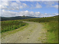
A track to the west of Shankend Farm
The twin summits in the distance are the Maiden Paps.
Image: © Walter Baxter
Taken: 28 Jul 2007
0.14 miles
2
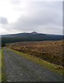
Access Track Near Penchrise Peel
A view of the road, providing access to the Whitrope Forest, beyond. The Maiden Paps can be seen in the distance.
Image: © James T M Towill
Taken: 27 Dec 2014
0.15 miles
3
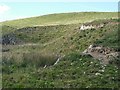
Small quarry by Penchrise Peel
Probably a source of road building material.
Image: © Richard Webb
Taken: 15 Sep 2009
0.16 miles