IMAGES TAKEN NEAR TO
HAWICK, TD9 9TW
Introduction
This page details the photographs taken nearby to TD9 9TW by members of the Geograph project.
The Geograph project started in 2005 with the aim of publishing, organising and preserving representative images for every square kilometre of Great Britain, Ireland and the Isle of Man.

There are currently over 7.5m images from over14,400 individuals and you can help contribute to the project by visiting https://www.geograph.org.uk
Image Map
Images are licensed for reuse under creativecommons.org/licenses/by-sa/2.0
Notes
- Clicking on the map will re-center to the selected point.
- The higher the marker number, the further away the image location is from the centre of the postcode.
Image Listing (13 Images Found)
Images are licensed for reuse under creativecommons.org/licenses/by-sa/2.0
Image
Details
Distance
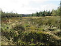
1
Lurgiescleuch near Hobkirk
I hurried on - unsure of which lurgie it was but taking no chances!
Image: © ian shiell
Taken: 8 Oct 2019
0.02 miles
2
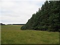
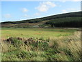
Established woodland, Lurgiescleuch
A small and long established plantation. The foreground has now been planted with conifers.
Image: © Richard Webb
Taken: 29 Aug 2008
0.07 miles
3
Bend in new track at Lurgiescleuch near Hobkirk
Image: © ian shiell
Taken: 8 Oct 2019
0.07 miles
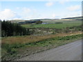
4
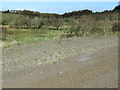
New plantation, Lurgiescleuch
There have been some big changes here since the last map was published. There are several new forestry blocks between the Newcastleton road and Lurgiescleuch. They are all small and so far a lot of the better drained land has remained grassland for sheep.
The wood in the background is a shelterbelt.
Image: © Richard Webb
Taken: 29 Aug 2008
0.10 miles
5
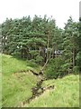
Pines Burn
Small stream entering established woodland.
Image: © Richard Webb
Taken: 29 Aug 2008
0.10 miles
6
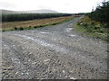
New track near Lurgiescleuch by Hobkirk in the Scottish Borders
Image: © ian shiell
Taken: 8 Oct 2019
0.11 miles
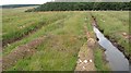
7
Course of Pines Burn in the Scottish Borders
Image: © ian shiell
Taken: 8 Oct 2019
0.12 miles
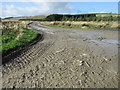
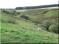
8
In the course of Lurgies Burn above Harwood in the Scottish Borders
Image: © ian shiell
Taken: 8 Oct 2019
0.12 miles
9
New track crossing Lurgies Burn by causeway
Image: © ian shiell
Taken: 8 Oct 2019
0.14 miles