IMAGES TAKEN NEAR TO
HAWICK, TD9 9SN
Introduction
This page details the photographs taken nearby to TD9 9SN by members of the Geograph project.
The Geograph project started in 2005 with the aim of publishing, organising and preserving representative images for every square kilometre of Great Britain, Ireland and the Isle of Man.

There are currently over 7.5m images from over14,400 individuals and you can help contribute to the project by visiting https://www.geograph.org.uk
Image Map
Images are licensed for reuse under creativecommons.org/licenses/by-sa/2.0
Notes
- Clicking on the map will re-center to the selected point.
- The higher the marker number, the further away the image location is from the centre of the postcode.
Image Listing (8 Images Found)
Images are licensed for reuse under creativecommons.org/licenses/by-sa/2.0
Image
Details
Distance
1

A6399, Crowbyres
Approaching Hawick in anticyclonic conditions.
Image: © Richard Webb
Taken: 2 Nov 2015
0.04 miles
2

Hawick from the air
Whitlaw Wood at the south end of the town is in the foreground.
Image: © Thomas Nugent
Taken: 9 Feb 2018
0.11 miles
3
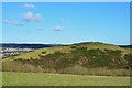
Hardie's Hill
Seen from the hill pasture near Whitlaw Wood. The Eildon Hills are peeping above the horizon, centre.
Image: © Jim Barton
Taken: 2 Feb 2013
0.12 miles
4
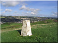
The trig point on Hardie's Hill
This trig point at 211m overlooks the town of Hawick in the Scottish Borders
Image: © Walter Baxter
Taken: 30 Sep 2006
0.19 miles
5
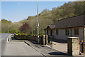
The first house in Hawick
As you enter Hawickon the B6399 this is the first house you see. It is quite likely to remain so as the valley is narrow and very twisty it is unlikely that houses could be built further out.
Image: © Malcolm Neal
Taken: 4 May 2017
0.19 miles
7
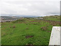
Wall-side view from Hardie's Hill Triangulation Pillar
Looking north-eastward.
Image: © Peter Wood
Taken: 13 Oct 2015
0.24 miles
8
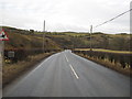
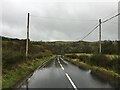
The B6399 heading for Hawick
Near Hummelknows.
Image: © James Denham
Taken: 25 Jan 2011
0.24 miles