IMAGES TAKEN NEAR TO
Thornwood Park, HAWICK, TD9 8LD
Introduction
This page details the photographs taken nearby to Thornwood Park, TD9 8LD by members of the Geograph project.
The Geograph project started in 2005 with the aim of publishing, organising and preserving representative images for every square kilometre of Great Britain, Ireland and the Isle of Man.

There are currently over 7.5m images from over14,400 individuals and you can help contribute to the project by visiting https://www.geograph.org.uk
Image Map
Images are licensed for reuse under creativecommons.org/licenses/by-sa/2.0
Notes
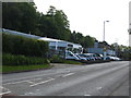
- Clicking on the map will re-center to the selected point.
- The higher the marker number, the further away the image location is from the centre of the postcode.
Image Listing (17 Images Found)
Images are licensed for reuse under creativecommons.org/licenses/by-sa/2.0
Image
Details
Distance
3
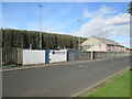
Hawick Community Recycling Centre
One of a number of commercial sites on the north bank of the River to the east of Hawick town centre.
Image: © Oliver Dixon
Taken: 22 Sep 2014
0.09 miles
4
Riverside path at Hawick
Heading along the River Teviot, from the Mansfield area of the town to the locally famous Hornshole Bridge
Image: © James Denham
Taken: 18 Jun 2016
0.10 miles
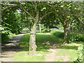
5
Albert Park. Home of Hawick Royal Albert United
Image: © Martin Dawes
Taken: 8 Sep 2019
0.10 miles
6
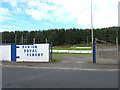
Hawick Royal Albert Football Club
The grounds of the Hawick Royal Albert Football Club adjoin the grounds of the Hawick Rugby Football Club on Mansfield Road.
Image: © Oliver Dixon
Taken: 22 Sep 2014
0.11 miles
7
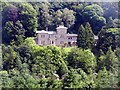
A view over the River Teviot at Hawick
The Mansfield House Hotel can be seen over the tree tops as seen from the Burnfoot area of the town.
Image: © James Denham
Taken: 18 Jun 2016
0.18 miles
8
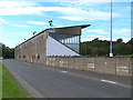
Mansfield Park, Hawick
Stand for the Hawick Rugby Football Club at Mansfield Park.
Image: © Oliver Dixon
Taken: 22 Sep 2014
0.18 miles
9

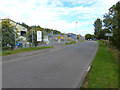
Burnfoot Industrial Estate, Hawick
Howdens joinery and kitchen construction and Barrie knitwear in this industrial estate on the NE side of the town.
Image: © Jim Barton
Taken: 2 Aug 2013
0.19 miles
10
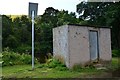
River monitoring station, Hawick
One of a network of stations maintained by the Scottish Environmental Protection Agency (SEPA) to record real-time river levels for flood warning and long-term assessment of water resources. The SEPA web page at http://www.sepa.org.uk/water/river_levels/river_level_data.aspx gives up-to-date data for the whole of Scotland river by river.
Image: © Jim Barton
Taken: 10 Aug 2012
0.19 miles