IMAGES TAKEN NEAR TO
NEWCASTLETON, TD9 0SP
Introduction
This page details the photographs taken nearby to TD9 0SP by members of the Geograph project.
The Geograph project started in 2005 with the aim of publishing, organising and preserving representative images for every square kilometre of Great Britain, Ireland and the Isle of Man.

There are currently over 7.5m images from over14,400 individuals and you can help contribute to the project by visiting https://www.geograph.org.uk
Image Map
Images are licensed for reuse under creativecommons.org/licenses/by-sa/2.0
Notes
- Clicking on the map will re-center to the selected point.
- The higher the marker number, the further away the image location is from the centre of the postcode.
Image Listing (11 Images Found)
Images are licensed for reuse under creativecommons.org/licenses/by-sa/2.0
Image
Details
Distance
1
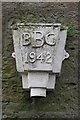
Drainpipe head, Saughton Grain
One of a pair used as a hanging basket. Wonder what BBC stood for? The obvious, or some borough council?
A lovely piece of ironwork.
I have since been told that BBC stands for the Barking Brassware Company. (thanks to Walter Baxter)
Image: © Richard Webb
Taken: 28 Sep 2009
0.02 miles
2
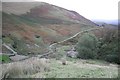
Saughtree Grain
Farm and outbuildings tucked away in the upper part of the Dawston Burn's catchment.
Image: © Richard Webb
Taken: 28 Sep 2009
0.15 miles
3
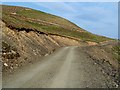
A forestry road at Saughtree Grain
A network of forestry roads has been constructed to access forestry planted on the hills around Saughtree Grain.
Image: © Walter Baxter
Taken: 2 May 2012
0.16 miles
4
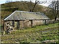
An old farm building at Saughtree Grain
Image: © Walter Baxter
Taken: 2 May 2012
0.19 miles
5

A culvert on the Cliffhope Burn
The culvert runs under a forestry road near Saughtree Grain.
Image: © Walter Baxter
Taken: 2 May 2012
0.20 miles
6
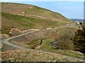
Forestry roads at Saughtree Grain
Forestry road construction and new planting on the hillsides around Saughtree Grain has taken place. For a similar view taken in 2009, see Image
Image: © Walter Baxter
Taken: 2 May 2012
0.20 miles
7
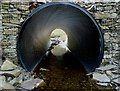
A culvert on the Cliffhope Burn
The culvert runs under a forestry road near Saughtree Grain.
Image: © Walter Baxter
Taken: 2 May 2012
0.20 miles
8
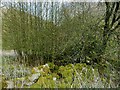
An interesting tree at Alison Sike
Half of a tree has collapsed and taken root resulting in this mini-forest of saplings. A crow was sitting on a nest on the upright remains of the original tree. The tree is beyond the two ash trees in this photo Image
Image: © Walter Baxter
Taken: 2 May 2012
0.20 miles
9
An interesting tree at Alison Sike
Half of a tree has collapsed and taken root resulting in this mini-forest of saplings. A crow was sitting on a nest on the upright remains of the original tree. The tree is beyond the two ash trees in this photo Image
Image: © Walter Baxter
Taken: 2 May 2012
0.20 miles
10
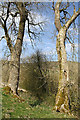
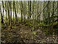
Trees at Alison Sike
These ash trees are on the northwest side of a small burn in the sike.
Image: © Walter Baxter
Taken: 2 May 2012
0.21 miles