IMAGES TAKEN NEAR TO
HAWICK, TD9 0JP
Introduction
This page details the photographs taken nearby to TD9 0JP by members of the Geograph project.
The Geograph project started in 2005 with the aim of publishing, organising and preserving representative images for every square kilometre of Great Britain, Ireland and the Isle of Man.

There are currently over 7.5m images from over14,400 individuals and you can help contribute to the project by visiting https://www.geograph.org.uk
Image Map
Images are licensed for reuse under creativecommons.org/licenses/by-sa/2.0
Notes
- Clicking on the map will re-center to the selected point.
- The higher the marker number, the further away the image location is from the centre of the postcode.
Image Listing (11 Images Found)
Images are licensed for reuse under creativecommons.org/licenses/by-sa/2.0
Image
Details
Distance
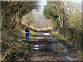
1
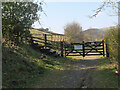
Steps to field path, Longbaulk farm
The path diverts into the field to head to Martinshouse on a route once known as the Fishermen's Walk (from the Nan Lyle Walk leaflet, Ian W Landles).
Image: © Jim Barton
Taken: 23 Mar 2022
0.06 miles
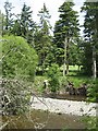
2
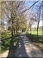
Riverside path, Wilton Lodge Park
A very attractive park by the River Teviot.
Image: © Oliver Dixon
Taken: 23 Apr 2015
0.07 miles
3
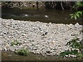
River Teviot
Exposed shingle with oystercatcher, upstream of Hawick.
Image: © Richard Webb
Taken: 21 Jun 2007
0.07 miles
4
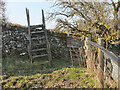
Stile on Nan Lyle Circular Walk near Hawick
The walk is a 12.5km (8 mi) route to commemorate Nan Lyle (1929 - 2010) a local woman for her considerable charity and community work in Hawick and overseas.
Image: © Jim Barton
Taken: 23 Mar 2022
0.08 miles
5
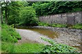
Shingle bank on the River Teviot
The main A7 road runs close by the river just beyond the wall, seen here from Wilton Lodge Park.
Image: © Jim Barton
Taken: 1 Jul 2012
0.09 miles
6
Track southwest of Hawick
The track continues from the end of Longbaulk Road to Longbaulk farm and Martinshouse. It was the main road out of Hawick until the valley route (now the A7) opened in 1815 (from the Nan Lyle Walk leaflet, Ian W Landles).
Image: © Jim Barton
Taken: 23 Mar 2022
0.10 miles
7
River Teviot
Low water as the river enters Hawick.
Image: © Richard Webb
Taken: 21 Jun 2007
0.12 miles
8
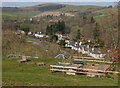
Houses by the A7 near Hawick
Looking from the field path above Longbaulk farm to Wiltonburn Hill (282m).
Image: © Jim Barton
Taken: 23 Mar 2022
0.13 miles
9

Hawick from the air
The River Teviot can be seen running through the centre of the town.
Image: © Thomas Nugent
Taken: 9 Feb 2018
0.21 miles
10
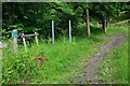
Millennium Nature Trail, Hawick
A path through the woods starting here by the Wilton Burn; note the 'Millenium' on the sign - a common spelling pitfall.
Image: © Jim Barton
Taken: 1 Jul 2012
0.24 miles