IMAGES TAKEN NEAR TO
JEDBURGH, TD8 6UR
Introduction
This page details the photographs taken nearby to TD8 6UR by members of the Geograph project.
The Geograph project started in 2005 with the aim of publishing, organising and preserving representative images for every square kilometre of Great Britain, Ireland and the Isle of Man.

There are currently over 7.5m images from over14,400 individuals and you can help contribute to the project by visiting https://www.geograph.org.uk
Image Map
Images are licensed for reuse under creativecommons.org/licenses/by-sa/2.0
Notes
- Clicking on the map will re-center to the selected point.
- The higher the marker number, the further away the image location is from the centre of the postcode.
Image Listing (9 Images Found)
Images are licensed for reuse under creativecommons.org/licenses/by-sa/2.0
Image
Details
Distance
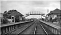
1
Site of Belses station, 1989
View northward, towards St Boswells and Edinburgh: ex-NBR Einburgh - Carlisle (Waverley Route) main line, closed completely 6/1/69. (See Image] for the station as it was in 1962.)
Image: © Ben Brooksbank
Taken: 30 Mar 1989
0.04 miles
2
Belses Station
View NE, towards St Boswells and Edinburgh; Edinburgh (Waverley) - Galashiels - St Boswells - Hawick - Carlisle (Waverley Route) main line. Belses station closed on 6/1/69, when the whole route (between Portobello East Junction and Carlisle No. 3 Box) was closed to passengers. Goods Edinburgh - Hawick (mainly coal from Lady Victoria Pit to Portobello) contined until 28/4/69 and Newtongrange - Millerhill remained intact until 28/6/72: Longtown - Brunthill lasted until 31/8/70, leaving only Brunthill - Carlisle open for goods. The closure of the Waverley Route was one of the most drastic of the Beeching Period, affecting the whole of the Border Counties. It was justified on the grounds of there being alternative Anglo-Scottish through routes, while the switch of rail traffic to road in a sparsely populated area had virtually obliterated the demand for local transport by rail. In the past 40 years, 'express' bus services have been deemed adequate to serve the populations of the Borders towns (such as Hawick) who are very young or very old and have no cars. However, as is well known, a new railway between Edinburgh and Galashiels is about to be built and consideration is being given to reopening the whole Waverley Route eventually.
Image: © Ben Brooksbank
Taken: 20 Sep 1962
0.06 miles
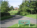
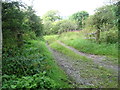
3
New Belses Farm
The track leading to the entrance to the farm.
Image: © James Denham
Taken: 25 Sep 2008
0.06 miles
5
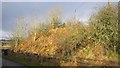
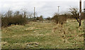
Site of a bridge, Belses Station
There was a bridge here once and a railway station just to the south. All went after the 1969 closure of the Waverley Line.
Image: © Richard Webb
Taken: 14 Feb 2013
0.11 miles
6
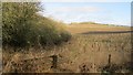
Young trees, Belses Station
Near the station site with an embankment on the left. The station was on the south side of the road.
Image: © Richard Webb
Taken: 14 Feb 2013
0.14 miles
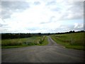
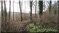
7
Track leading off the Rawflat to Old Belses road
The track heads off a steep bend on the road.
Image: © James Denham
Taken: 2 Sep 2012
0.14 miles
9
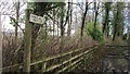
Footpath sign, Rawflat
Rawflat Path 2.2km. It points along the edge of a strip wood.
Image: © Richard Webb
Taken: 14 Feb 2013
0.23 miles