Belses Station
Introduction
The photograph on this page of Belses Station by Ben Brooksbank as part of the Geograph project.
The Geograph project started in 2005 with the aim of publishing, organising and preserving representative images for every square kilometre of Great Britain, Ireland and the Isle of Man.

There are currently over 7.5m images from over 14,400 individuals and you can help contribute to the project by visiting https://www.geograph.org.uk
Belses Station
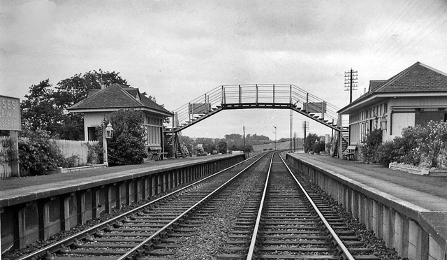
Image: © Ben Brooksbank Taken: 20 Sep 1962
View NE, towards St Boswells and Edinburgh; Edinburgh (Waverley) - Galashiels - St Boswells - Hawick - Carlisle (Waverley Route) main line. Belses station closed on 6/1/69, when the whole route (between Portobello East Junction and Carlisle No. 3 Box) was closed to passengers. Goods Edinburgh - Hawick (mainly coal from Lady Victoria Pit to Portobello) contined until 28/4/69 and Newtongrange - Millerhill remained intact until 28/6/72: Longtown - Brunthill lasted until 31/8/70, leaving only Brunthill - Carlisle open for goods. The closure of the Waverley Route was one of the most drastic of the Beeching Period, affecting the whole of the Border Counties. It was justified on the grounds of there being alternative Anglo-Scottish through routes, while the switch of rail traffic to road in a sparsely populated area had virtually obliterated the demand for local transport by rail. In the past 40 years, 'express' bus services have been deemed adequate to serve the populations of the Borders towns (such as Hawick) who are very young or very old and have no cars. However, as is well known, a new railway between Edinburgh and Galashiels is about to be built and consideration is being given to reopening the whole Waverley Route eventually.
Images are licensed for reuse under creativecommons.org/licenses/by-sa/2.0
Image Location
Latitude
55.518232
Longitude
-2.676218