IMAGES TAKEN NEAR TO
JEDBURGH, TD8 6QX
Introduction
This page details the photographs taken nearby to TD8 6QX by members of the Geograph project.
The Geograph project started in 2005 with the aim of publishing, organising and preserving representative images for every square kilometre of Great Britain, Ireland and the Isle of Man.

There are currently over 7.5m images from over14,400 individuals and you can help contribute to the project by visiting https://www.geograph.org.uk
Image Map
Images are licensed for reuse under creativecommons.org/licenses/by-sa/2.0
Notes
- Clicking on the map will re-center to the selected point.
- The higher the marker number, the further away the image location is from the centre of the postcode.
Image Listing (3 Images Found)
Images are licensed for reuse under creativecommons.org/licenses/by-sa/2.0
Image
Details
Distance
1
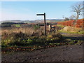
Sign for Jedburgh Circular route
Both a walk and a horseriding route, this passes through woods and farmland to the east of the town, here by the crossing point of the Oxnam road.
Image: © Jim Barton
Taken: 18 Nov 2012
0.13 miles
2
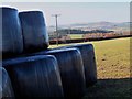
Silage bales near Over Thickside
Looking across the valley of the Jed Water to Dunion Hill and Black Law.
Image: © Jim Barton
Taken: 18 Nov 2012
0.14 miles
3
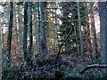
Natural Wood near Over Thickside
Perhaps the name of Natural Wood arises from the mix of tree species on this estate land.
Image: © Jim Barton
Taken: 18 Nov 2012
0.17 miles