IMAGES TAKEN NEAR TO
SELKIRK, TD7 4NZ
Introduction
This page details the photographs taken nearby to TD7 4NZ by members of the Geograph project.
The Geograph project started in 2005 with the aim of publishing, organising and preserving representative images for every square kilometre of Great Britain, Ireland and the Isle of Man.

There are currently over 7.5m images from over14,400 individuals and you can help contribute to the project by visiting https://www.geograph.org.uk
Image Map
Images are licensed for reuse under creativecommons.org/licenses/by-sa/2.0
Notes
- Clicking on the map will re-center to the selected point.
- The higher the marker number, the further away the image location is from the centre of the postcode.
Image Listing (12 Images Found)
Images are licensed for reuse under creativecommons.org/licenses/by-sa/2.0
Image
Details
Distance
1
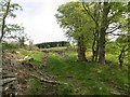
Blaeberry Plantation
This bit has been felled.
Image: © Richard Webb
Taken: 11 May 2014
0.00 miles
2
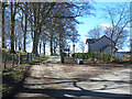
"The Beeches"
Aptly-named new house beside the Wollrig road.
Image: © Oliver Dixon
Taken: 24 Mar 2014
0.02 miles
4
Wollrig
Bikes on the climb carried numbers, another of the now common organised rides. I have yet to brave this side of the climb but have crossed the pass by an offroad route. It's a long way up.
Image: © Richard Webb
Taken: 11 May 2014
0.10 miles
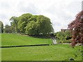
5

Bullocks at Wollrig
Rolling Border country.
Image: © Oliver Dixon
Taken: 7 Oct 2009
0.10 miles
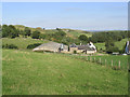
6
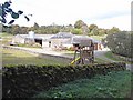
Wollrig Farm
The playhouse is on the adjoining property.
Image: © Oliver Dixon
Taken: 7 Oct 2009
0.10 miles
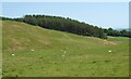
7
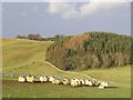
Sheep at Wollrig
Wollrig Plantation is beyond.
Image: © Walter Baxter
Taken: 21 Jan 2007
0.13 miles
9
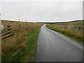
Minor road near to Wollrig
Looking north-westward.
Image: © Peter Wood
Taken: 28 Sep 2021
0.19 miles
10
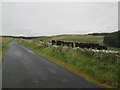
Sheep in pasture near Wollrig
Wollrig Plantation beyond the wall.
Image: © Russel Wills
Taken: 13 Jun 2023
0.21 miles