IMAGES TAKEN NEAR TO
Bleachfield Road, SELKIRK, TD7 4HZ
Introduction
This page details the photographs taken nearby to Bleachfield Road, TD7 4HZ by members of the Geograph project.
The Geograph project started in 2005 with the aim of publishing, organising and preserving representative images for every square kilometre of Great Britain, Ireland and the Isle of Man.

There are currently over 7.5m images from over14,400 individuals and you can help contribute to the project by visiting https://www.geograph.org.uk
Image Map (Loading...)


Getting Data...Please wait
Leaflet Map data © OpenStreetMap
Images are licensed for reuse under creativecommons.org/licenses/by-sa/2.0
Notes
- Clicking on the map will re-center to the selected point.
- The higher the marker number, the further away the image location is from the centre of the postcode.
Image Listing (7 Images Found)
Images are licensed for reuse under creativecommons.org/licenses/by-sa/2.0
Image
Details
Distance
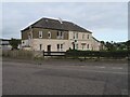
1

Bridgelands Road, Selkirk
Looking north-eastward.
Image: © Peter Wood
Taken: 29 Sep 2021
0.07 miles
2
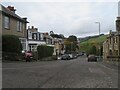
Raeburn Place, Selkirk
Mixed housing styles; looking down towards the A7 and the valley of the Ettrick Water.
Image: © M J Richardson
Taken: 16 Oct 2023
0.09 miles
3
The A7 heading north
Leaving Selkirk at Raeburn Place heading for Galashiels
Image: © James Denham
Taken: 29 May 2008
0.14 miles
4
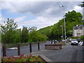
Housing estate at Selkirk
In groups of four, semidetached upper and lower flats. The right hand pair are 1 & 3 Shawburn Road, the left hand pair are 18 & 20 Raeburn Meadow.
Image: © M J Richardson
Taken: 16 Oct 2023
0.20 miles
5
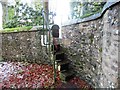
Entrance Steps
These steps provide a short cut over the high wall into Shawfield Cemetery from Shawpark Road
Image: © Adam D Hope
Taken: 26 Dec 2017
0.23 miles
6
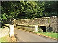
Two bridges over the Shaw Burn in Selkirk
The bridge on the left is within Shawpark Cemetery while over the high rubble wall to the right is the road from Selkirk to Halfcrown Corner. Both bridges span the Shaw Burn.
Image: © Walter Baxter
Taken: 21 Sep 2006
0.23 miles
7
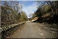
An old road at Selkirk
This short section of road used to link Ettrick Terrace (A7) with Dunsdale Road, but it is now only accessible by pedestrians since a new junction was formed 500m to the north-northeast at the A7.
Image: © Walter Baxter
Taken: 14 Mar 2010
0.24 miles