IMAGES TAKEN NEAR TO
Heathpark Place, SELKIRK, TD7 4DN
Introduction
This page details the photographs taken nearby to Heathpark Place, TD7 4DN by members of the Geograph project.
The Geograph project started in 2005 with the aim of publishing, organising and preserving representative images for every square kilometre of Great Britain, Ireland and the Isle of Man.

There are currently over 7.5m images from over14,400 individuals and you can help contribute to the project by visiting https://www.geograph.org.uk
Image Map
Images are licensed for reuse under creativecommons.org/licenses/by-sa/2.0
Notes
- Clicking on the map will re-center to the selected point.
- The higher the marker number, the further away the image location is from the centre of the postcode.
Image Listing (61 Images Found)
Images are licensed for reuse under creativecommons.org/licenses/by-sa/2.0
Image
Details
Distance
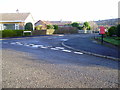
1
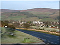
Selkirk from the carpark on the A699
View of the Hillside area of Selkirk and showing in particular Selkirk High School
Image: © Mark Hope
Taken: 6 Mar 2009
0.01 miles
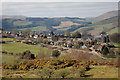
2
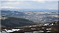
Selkirk
A view of the town from Foulshiels Hill with a very snowy Cheviot in the background. Selkirk looks a lot bigger from here than it feels like on the ground.
Image: © Richard Webb
Taken: 6 Apr 2013
0.07 miles
3

Ladylands area of Selkirk
Ladylands viewed from the edge of the golf course. The Pot loch is just visible on the right.
Image: © Mark Hope
Taken: 6 Mar 2009
0.12 miles
4
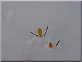
Crocus Spring 2013
Garden Ladylands Terrace in late March the plants beating the elements
Image: © Adam D Hope
Taken: 22 Mar 2013
0.12 miles
5
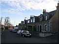
Hill Street
Terraced houses across the road from Selkirk High School.
Image: © Richard Webb
Taken: 9 Nov 2007
0.13 miles
6
Hillview Crescent
Entrance to Hillview Crescent from Ladylands Terrace with Post BOX
Image: © Adam D Hope
Taken: 24 Dec 2013
0.14 miles
7
Selkirk seen from Selkirk Hills
An attractive view of the east side of the town from one of the many paths through Selkirk Hills. The High School is to the right.
Image: © Jim Barton
Taken: 1 Apr 2012
0.15 miles

9

The Pot Loch in Sellkirk
The loch, in days gone by, was used as a curling pond and is now classified as one of Scotland's historic curling venues. Curling was still being played well in to the 20th. century.
Image: © James Denham
Taken: 31 Mar 2013
0.16 miles
10
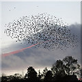
A starling murmuration at Selkirk
Around 1000 birds gather at dusk before roosting in a reed bed at the Pot Loch. For a view of the reed bed and loch, see Image
Image: © Walter Baxter
Taken: 12 Nov 2016
0.18 miles