IMAGES TAKEN NEAR TO
The Loan, SELKIRK, TD7 4AU
Introduction
This page details the photographs taken nearby to The Loan, TD7 4AU by members of the Geograph project.
The Geograph project started in 2005 with the aim of publishing, organising and preserving representative images for every square kilometre of Great Britain, Ireland and the Isle of Man.

There are currently over 7.5m images from over14,400 individuals and you can help contribute to the project by visiting https://www.geograph.org.uk
Image Map
Images are licensed for reuse under creativecommons.org/licenses/by-sa/2.0
Notes
- Clicking on the map will re-center to the selected point.
- The higher the marker number, the further away the image location is from the centre of the postcode.
Image Listing (206 Images Found)
Images are licensed for reuse under creativecommons.org/licenses/by-sa/2.0
Image
Details
Distance
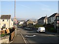
1
South Port, Selkirk
The route of the Borders Abbeys Way down to the Market Place and town centre.
Image: © Jim Barton
Taken: 1 Mar 2011
0.04 miles
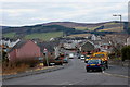
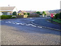
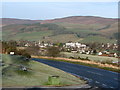
2
The Loan, Selkirk
Residential street and rat run for those of us anxious not to be following a lorry through the town on the A7.
Image: © Richard Webb
Taken: 7 May 2008
0.07 miles
3
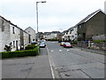
The Loan, Selkirk
The Borders Abbeys Way, a circular long-distance walking route in the Scottish Borders, passes along this suburban street on the way from Selkirk Hill down into Selkirk town centre.
Image: © Oliver Dixon
Taken: 4 May 2014
0.08 miles
4
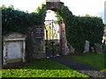
"Kirk o' the Forest"
It was on this site that William Wallace was named as Guardian following his victory at Stirling Bridge in 1297. The kirk in the picture was completed in 1747 to replace the pre-Reformation building but fell into ruin after it was abandoned in 1861. Some of the maternal ancestors of Franklin D Roosevelt are buried in the graveyard.
Image: © Euan Nelson
Taken: 24 Nov 2007
0.09 miles
5
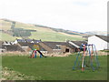
Children's play area
This children's play area is at Sentryknowe Selkirk.
Image: © Mark Hope
Taken: 15 Mar 2009
0.13 miles
6

Ladylands area of Selkirk
Ladylands viewed from the edge of the golf course. The Pot loch is just visible on the right.
Image: © Mark Hope
Taken: 6 Mar 2009
0.14 miles
7
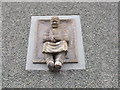
The Soutars o' Selkirk
A frieze depicting a souter (shoemaker) on the gable end of a more modern building. Shoemakers were the largest of the trades in the town of Selkirk in the Scottish Borders, thus the nickname of the natives of the town - Soutars.
Image: © James Denham
Taken: 18 May 2011
0.14 miles
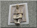
8
Statue of Souter, Selkirk
Souter is the Scots name for shoemaker.
Shoemaking was the main trade in Selkirk until the textile trade arrived - the Shoemakers' Guild was founded in 1609 and survived until the 1960s. The trade lived on until 1975 when John Guthrie, the last shoemaker, retired. This statue on Kirk Wynd in the area known as Selkirk Regis is a monument to the great tradition. Many people surnamed Souter still live in Selkirk.
(Information from Town Trail booklet.)
Image: © Barbara Carr
Taken: 3 Jun 2013
0.15 miles
9
Hillview Crescent
Entrance to Hillview Crescent from Ladylands Terrace with Post BOX
Image: © Adam D Hope
Taken: 24 Dec 2013
0.15 miles
10
Selkirk from the carpark on the A699
View of the Hillside area of Selkirk and showing in particular Selkirk High School
Image: © Mark Hope
Taken: 6 Mar 2009
0.16 miles