IMAGES TAKEN NEAR TO
Wooden Linn, KELSO, TD5 8HY
Introduction
This page details the photographs taken nearby to Wooden Linn, TD5 8HY by members of the Geograph project.
The Geograph project started in 2005 with the aim of publishing, organising and preserving representative images for every square kilometre of Great Britain, Ireland and the Isle of Man.

There are currently over 7.5m images from over14,400 individuals and you can help contribute to the project by visiting https://www.geograph.org.uk
Image Map (Loading...)


Getting Data...Please wait
Leaflet Map data © OpenStreetMap
Images are licensed for reuse under creativecommons.org/licenses/by-sa/2.0
Notes
- Clicking on the map will re-center to the selected point.
- The higher the marker number, the further away the image location is from the centre of the postcode.
Image Listing (38 Images Found)
Images are licensed for reuse under creativecommons.org/licenses/by-sa/2.0
Image
Details
Distance
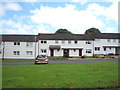
2
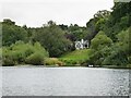
Bungalow overlooking the River Tweed
With pair of swans, bottoms up, and a heron resting on foreshore.
Image: © Russel Wills
Taken: 31 Aug 2021
0.07 miles
3

Approaching Hunter Bridge at Kelso from the south
Hunter Bridge carrying the A698 road over the River Tweed was built between 1997 and 1998 to reduce the congestion on the 1804 John Rennie bridge and direct traffic around the edge of the town.
Image: © Walter Baxter
Taken: 16 Oct 2009
0.07 miles
4
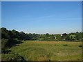
Summer in Kelso
Looking upstream from the "New" bridge over Crown Point to the Mayfield area of Kelso.
See Image for winter flood.
Image: © Hill Walker
Taken: 12 Jul 2005
0.07 miles
5
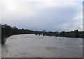
River Tweed in Flood
Looking upstream from the "New" bridge to a flooded Mayfield. See image Image for the same view on a summer's day.
Image: © Hill Walker
Taken: 8 Jan 2005
0.07 miles
6

Kelso Branch Railway
A simple path along the trackbed of the Kelso Branch line. No tarring or excessive attacks on the new woodland. This is like the railway west of Peebles or some of the railway paths I have recently encountered in Wallonia, one to explore rather than another extension of the road network. Not that I have anything against Sustrans - keep up the good work, but these paths are really special.
Not that the trees let on, but here the path is crossing a high bridge over a road and soon the path ends as the trackbed has been used for the Kelso bypass.
Image: © Richard Webb
Taken: 28 Jun 2011
0.09 miles
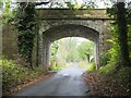
7
Railway bridge
Ivy almost hides a bridge which once carried the Kelso Branch Railway. A path now runs over it.
Image: © Richard Webb
Taken: 28 Jun 2011
0.11 miles
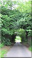
8
Ivy clad railway bridge, Kelso
The former line is now a footpath between Kelso and Sprouston and points further east. This bridge spans the minor road to Easter Softlaw and the B6396.
Image: © Jim Barton
Taken: 30 Apr 2013
0.11 miles
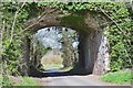
9
Former railway bridge, Kelso
The former line to Berwick is now a surfaced cyclepath as far as Sprouston, and is a footpath beyond there. Access here is to the left under the bridge.
Image: © Jim Barton
Taken: 15 Oct 2020
0.11 miles
10
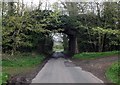
Bridge between Kelso and Wooden
Which once carried the Kelso to Berwick railway.
Image: © James Denham
Taken: 28 Apr 2014
0.12 miles