IMAGES TAKEN NEAR TO
Sprouston Road, KELSO, TD5 8ET
Introduction
This page details the photographs taken nearby to Sprouston Road, TD5 8ET by members of the Geograph project.
The Geograph project started in 2005 with the aim of publishing, organising and preserving representative images for every square kilometre of Great Britain, Ireland and the Isle of Man.

There are currently over 7.5m images from over14,400 individuals and you can help contribute to the project by visiting https://www.geograph.org.uk
Image Map
Images are licensed for reuse under creativecommons.org/licenses/by-sa/2.0
Notes
- Clicking on the map will re-center to the selected point.
- The higher the marker number, the further away the image location is from the centre of the postcode.
Image Listing (49 Images Found)
Images are licensed for reuse under creativecommons.org/licenses/by-sa/2.0
Image
Details
Distance
1
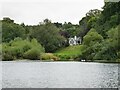
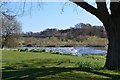
Bungalow overlooking the River Tweed
With pair of swans, bottoms up, and a heron resting on foreshore.
Image: © Russel Wills
Taken: 31 Aug 2021
0.01 miles
2

Approaching Hunter Bridge at Kelso from the south
Hunter Bridge carrying the A698 road over the River Tweed was built between 1997 and 1998 to reduce the congestion on the 1804 John Rennie bridge and direct traffic around the edge of the town.
Image: © Walter Baxter
Taken: 16 Oct 2009
0.08 miles
4

The Tweed and Hunter Bridge, Kelso
Smooth water in the foreground becomes turbulent as it flows over the cauld (weir) between the left bank and the end of Wooden Anna island to the right. Water diverted around the right-hand side of Wooden Anna powered Wooden Mill before returning to the main river. The bridge carries the A698 Kelso by-pass.
Image: © Jim Barton
Taken: 17 Jan 2022
0.09 miles
5

Hunter Bridge at Kelso
Hunter Bridge carrying the A698 road over the River Tweed was built between 1997 and 1998 to reduce the congestion on the 1804 John Rennie bridge and direct traffic around the edge of the town.
Image: © Walter Baxter
Taken: 16 Oct 2009
0.09 miles
6
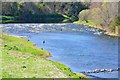
Anglers on the Tweed, Kelso
Fishing in the river downstream of the cauld. The island of Wooden Anna is on the left, separated from the bank by a narrow channel out of shot to the left. The viewpoint is Hunter Bridge.
Image: © Jim Barton
Taken: 30 Apr 2013
0.10 miles
7
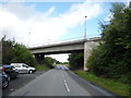
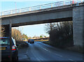
A698 bridge over the B6350, Kelso
Looking north east.
Image: © JThomas
Taken: 8 Sep 2016
0.10 miles
8
Road under Hunter Bridge, Kelso
The B6350 to Sprouston passes under the viaduct approach carrying the A698 to Hunter Bridge across the Tweed.
Image: © Jim Barton
Taken: 17 Jan 2022
0.10 miles
9
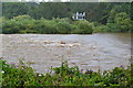
Plenty of August rain going over cauld at Kelso
Image: © David Martin
Taken: 18 Aug 2017
0.10 miles
10
Cauld on the Tweed, Kelso
The cauld (weir) diverted water to Wooden Mill downstream on the opposite bank, the other side of the oddly named Wooden Anna island. Wooden is an area name on the S side of the river here, with Wooden House, Wooden Farm and Wooden Dean. Hunter Bridge is in the background.
Image: © Jim Barton
Taken: 30 Apr 2013
0.10 miles