IMAGES TAKEN NEAR TO
Belmont Place, KELSO, TD5 7JB
Introduction
This page details the photographs taken nearby to Belmont Place, TD5 7JB by members of the Geograph project.
The Geograph project started in 2005 with the aim of publishing, organising and preserving representative images for every square kilometre of Great Britain, Ireland and the Isle of Man.

There are currently over 7.5m images from over14,400 individuals and you can help contribute to the project by visiting https://www.geograph.org.uk
Image Map
Images are licensed for reuse under creativecommons.org/licenses/by-sa/2.0
Notes
- Clicking on the map will re-center to the selected point.
- The higher the marker number, the further away the image location is from the centre of the postcode.
Image Listing (406 Images Found)
Images are licensed for reuse under creativecommons.org/licenses/by-sa/2.0
Image
Details
Distance
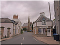
1
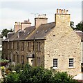
Row of houses near the north bank of the River Tweed
These houses were photographed from the bridge.
Image: © Ian Hawfinch
Taken: 28 Jun 2021
0.02 miles
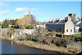
2
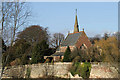
St Andrew's Episcopal Church, Kelso
This church (1869) is on the northeast side of the River Tweed and is viewed from the southwest end of Kelso Bridge.
Image: © Walter Baxter
Taken: 12 Mar 2009
0.02 miles
3
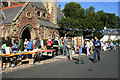
St Andrew's Church summer sale
The weather was kind to the organisers of this fund raising event at Belmont Place in Kelso. The church minister was doing his part by announcing over a megaphone that bargains were to be had.
Image: © Walter Baxter
Taken: 29 Aug 2009
0.02 miles
4
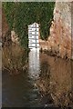
A river depth indicator at Kelso
This indicator marked in feet on the River Tweed was viewed from Kelso Bridge. For a wider view of the river from the bridge, see Image
Image: © Walter Baxter
Taken: 28 Dec 2013
0.03 miles
5
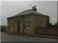
Old toll house
The bridge tollhouse at the town end of the old River Tweed at Kelso on a wet, dull day. Nothing to be seen through the windows so now unoccupied.
Image: © Chris Minto
Taken: 20 Oct 2022
0.03 miles
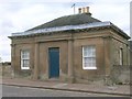
6
Toll House, Kelso Bridge
The bridge over the Tweed replaced an earlier stone bridge which was damaged by flooding in 1797. Its replacement was built under the direction of John Rennie and opened in 1803, with tolls ranging from 6 shillings for a vehicle drawn by 6 horses to a halfpenny for a pedestrian. As time went by, resentment against the tolls grew until in 1854 a mob tossed the toll gate into the river. Tolls were annulled in 1857. (Source: 'Bridging the Tweed' by Jim Lyon, author publication 2019).
Image: © Jim Barton
Taken: 31 Jul 2020
0.03 miles
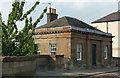
7
Former Tollhouse by the A698, Kelso Road, Kelso
Bridge End Cottage by the A698, in parish of Kelso (District), Catch a Penny, Kelso Road, Kelso.
HES Scotland Category 'A' listed.
Reference: LB35724 http://portal.historicenvironment.scot/designation/LB35724
Surveyed
Milestone Society National ID: SBD.KEL02
Image: © Milestone Society
Taken: 1 Jan 2009
0.03 miles
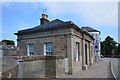
8
Bridge End Cottage, Kelso Bridge Toll House
Category A Listed toll house by John Rennie (the Elder 1761-1821) built presumably about the same time as the bridge 1800-1803. To repay the construction loan, the bridge was tolled until riots prompted their abandonment. Reports vary on the date of abandonment from 1854 the year of the riots to 1857 3 years after.
Image: © Jo and Steve Turner
Taken: 26 Jun 2010
0.04 miles
9
Abbey Court, Kelso
St Andrew's Episcopal Church in the background.
Image: © wfmillar
Taken: 26 Sep 2010
0.04 miles
10
Kelso : River Tweed
Kelso (Scottish Gaelic: Cealsaidh, Scots: Kelsae) is a market town and civil parish in the Scottish Borders, located where the rivers Tweed and Teviot meet. The parish has a population of 6,385. Kelso is regarded as one of the most charming and quaint towns in the area with its cobbled streets, elegant Georgian buildings and Flemish style cobbled market square. The town's other main tourist attractions are the ruined Kelso Abbey and Floors Castle, a William Adam designed house completed in 1726. The bridge at Kelso was designed by John Rennie, who later built both London Bridge and Waterloo Bridge in London.
The town came into being as a direct result of the creation of Kelso Abbey in 1128. Its name stems from the fact that the earliest settlement stood on a chalky outcrop, and the town was known as Calkou, or perhaps Calchfynydd, in those early days.
Standing on the opposite bank of the River Tweed from the now-vanished royal burgh of Roxburgh, Kelso and its sister hamlet, Wester Kelso, were linked to the burgh by a ferry. A small hamlet existed before the completion of the Abbey in 1128 but the settlement started to flourish with the arrival of the monks. Many were skilled craftsmen, and they helped the local population as the village expanded. The Abbey controlled much of life in Kelso until the Reformation in the 16th century. After that, the power and wealth of the Abbey declined. The Kerr family of Cessford took over the barony and many of the Abbey's properties around the town. By the 17th century, they virtually owned Kelso.
In Roxburgh Street is the outline of a horseshoe petrosomatoglyph where the horse of Charles Edward Stuart cast a shoe as he was riding it through the town on his way to Carlisle in 1745. He is also said to have planted a white rosebush in his host's garden, descendants of which are still said to flourish in the neighbourhood.
Wikipedia: http://en.wikipedia.org/wiki/Kelso,_Scottish_Borders
Image: © Ken Bagnall
Taken: 18 Mar 2011
0.04 miles