IMAGES TAKEN NEAR TO
Roosevelt Place, Melrose Road, EARLSTON, TD4 6DN
Introduction
This page details the photographs taken nearby to Roosevelt Place, Melrose Road, TD4 6DN by members of the Geograph project.
The Geograph project started in 2005 with the aim of publishing, organising and preserving representative images for every square kilometre of Great Britain, Ireland and the Isle of Man.

There are currently over 7.5m images from over14,400 individuals and you can help contribute to the project by visiting https://www.geograph.org.uk
Image Map
Images are licensed for reuse under creativecommons.org/licenses/by-sa/2.0
Notes
- Clicking on the map will re-center to the selected point.
- The higher the marker number, the further away the image location is from the centre of the postcode.
Image Listing (69 Images Found)
Images are licensed for reuse under creativecommons.org/licenses/by-sa/2.0
Image
Details
Distance
1
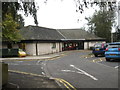
The Health Centre at Earlston in Berwickshire
Image: © James Denham
Taken: 16 Sep 2011
0.05 miles
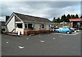
2
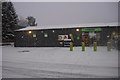
Co-op, Earlston
Newly expanded shop at the filling station.
Image: © Richard Webb
Taken: 8 Jan 2016
0.05 miles
3
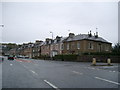
Thorn Street, Earlston
I always feel the house on the corner should be a bank. Junction is of the A68 and the A6105.
Image: © Kirsty Smith
Taken: 22 Oct 2005
0.05 miles
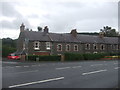
4
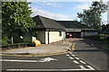
Earlston Health Centre
The health centre is located in Kidgate at the western edge of Earlston. It was built in 1983 and extended in 1994. The accommodation includes 3 Consulting Rooms, Practice Nurse Room and Health Visitor/Health Education/Physiotherapy facilities.
Image: © Walter Baxter
Taken: 30 Jul 2009
0.06 miles
5
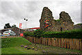
Rhymer's Tower, Earlston
The remains of a 16th century tower house beside Rutherfords Garage and Rhymer’s Tower Coffee Shop on the west side of the A68. The tower is held by the Edinburgh Borders Association.
Image: © Walter Baxter
Taken: 4 Sep 2009
0.07 miles
6
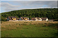
A grazing field at Earlston
This field adjacent to the health centre is grazed by some horses. The woodland in the background is on White Hill.
Image: © Walter Baxter
Taken: 30 Jul 2009
0.08 miles
8
The Rhymers Tower Coffee Shop and Restaurant
The coffee shop is at the south side of Earlston by the A68.
Image: © Walter Baxter
Taken: 8 Sep 2012
0.08 miles
9
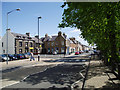
Earlston
View along the main street of this picturesque town.
Image: © Kevin Rae
Taken: 27 May 2006
0.08 miles
10
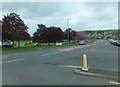
Junction of the A6105 and the A68
At the western end of Earlston High Street (A6105). From this point, the A68 north (pictured) is known as Lauder Road - to the south it is called Melrose Road.
Image: © Barbara Carr
Taken: 27 May 2013
0.09 miles