IMAGES TAKEN NEAR TO
LAUDER, TD2 6RZ
Introduction
This page details the photographs taken nearby to TD2 6RZ by members of the Geograph project.
The Geograph project started in 2005 with the aim of publishing, organising and preserving representative images for every square kilometre of Great Britain, Ireland and the Isle of Man.

There are currently over 7.5m images from over14,400 individuals and you can help contribute to the project by visiting https://www.geograph.org.uk
Image Map (Loading...)


Getting Data...Please wait
Leaflet Map data © OpenStreetMap
Images are licensed for reuse under creativecommons.org/licenses/by-sa/2.0
Notes
- Clicking on the map will re-center to the selected point.
- The higher the marker number, the further away the image location is from the centre of the postcode.
Image Listing (10 Images Found)
Images are licensed for reuse under creativecommons.org/licenses/by-sa/2.0
Image
Details
Distance
1
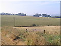
Whitslaid Farm
Looking across barley stubbles and pasture from near the Shaw Burn.
Image: © M J Richardson
Taken: 6 Oct 2007
0.03 miles
2
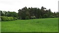
Barley field, Whitslaid
The field has a sheltering strip wood on the uphill side.
Image: © Richard Webb
Taken: 29 May 2012
0.14 miles
3
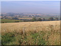
The valley of the Leader Water
Looking across barley stubble from Under Boon farm, towards where the Shaw Burn joins the Leader Water.
Image: © M J Richardson
Taken: 6 Oct 2007
0.22 miles
4
Whitslaid Tower
A Lauderdale tower house.
Image: © Richard Webb
Taken: 19 Sep 2011
0.24 miles
5
Whitslaid Tower
Former seat of the Lauder family.
Image: © Richard Webb
Taken: 29 May 2012
0.24 miles
6
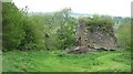
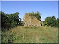
Whitslaid Tower
These are the ruins of a late 15th century or early 16th century tower house of the Lauder family. The north end of the tower has collapsed but part of the south end survives.
Image: © Walter Baxter
Taken: 6 Mar 2023
0.24 miles
7
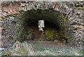
A barrel-vaulted chamber at Whitslaid Tower
This is at the south end of a late 15th century or early 16th century ruined tower house of the Lauder family.
Image: © Walter Baxter
Taken: 6 Mar 2023
0.24 miles
8
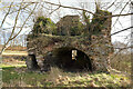
Whitslaid Tower
These are the ruins of a late 15th century or early 16th century tower house of the Lauder family. The north end of the tower has collapsed but this part at the south end survives.
Image: © Walter Baxter
Taken: 6 Mar 2023
0.24 miles
9
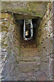
A stair at Whitslaid Tower
This stone staircase on the east side of a barrel-vaulted chamber leads to a first floor hall.
Image: © Walter Baxter
Taken: 6 Mar 2023
0.24 miles
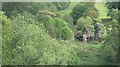
10
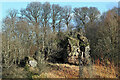
The remains of Whitslaid Tower near the Leader Water
Image: © Walter Baxter
Taken: 23 Sep 2006
0.25 miles