IMAGES TAKEN NEAR TO
Brewery Lane, BERWICK-UPON-TWEED, TD15 2AH
Introduction
This page details the photographs taken nearby to Brewery Lane, TD15 2AH by members of the Geograph project.
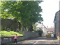
The Geograph project started in 2005 with the aim of publishing, organising and preserving representative images for every square kilometre of Great Britain, Ireland and the Isle of Man.

There are currently over 7.5m images from over14,400 individuals and you can help contribute to the project by visiting https://www.geograph.org.uk
Image Map (Loading...)


Getting Data...Please wait
Leaflet Map data © OpenStreetMap
Images are licensed for reuse under creativecommons.org/licenses/by-sa/2.0
Notes
- Clicking on the map will re-center to the selected point.
- The higher the marker number, the further away the image location is from the centre of the postcode.
Image Listing (237 Images Found)
Images are licensed for reuse under creativecommons.org/licenses/by-sa/2.0
Image
Details
Distance
1
Mill Strand, Tweedmouth
Looking northwest towards the harbour.
Image: © Barbara Carr
Taken: 30 Aug 2010
0.01 miles
2
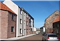
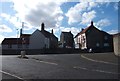
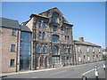
Refurbished buildings on Brewery Lane
See http://www.foodheritage-berwick.org.uk/Local_Food_Past/Plough%20Pub/11.htm for history and an old picture of Brewery Lane.
Image: © Barbara Carr
Taken: 30 Aug 2010
0.02 miles
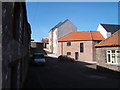
3
Brewery Lane, Tweedmouth
Seen from the junction with Brewery Bank - this area was home to the Border Brewery, see http://www.foodheritage-berwick.org.uk/Local_Food_Past/Plough%20Pub/11.htm .
Image: © Barbara Carr
Taken: 30 Aug 2010
0.02 miles
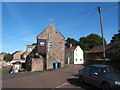
4
Top of Brewery Lane, Tweedmouth
Approaching the junction with Main Street.
Image: © Barbara Carr
Taken: 30 Aug 2010
0.02 miles
6
Junction of Main Street and Prince Edward Road
The Main Street of Tweedmouth meets the A1167 (Prince Edward Road, also known as 'the old A1').
Image: © Barbara Carr
Taken: 30 Aug 2010
0.04 miles
7
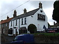
The Angel Inn
A Belhaven Best public house.
Image: © JThomas
Taken: 30 Apr 2015
0.04 miles
8
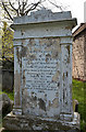
A memorial to John Mackay Wilson in Tweedmouth Parish Churchyard
John Mackay Wilson was the author of Wilson’s Tales of the Borders. He was born at Tweedmouth on 15th August 1804 and died on 2nd October 1835.
Image: © Walter Baxter
Taken: 28 Apr 2019
0.04 miles
10
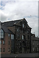
3 Dock Road, Tweedmouth
Tweedmouth Character Appraisal informs us this was the former warehouse of Border Brewery Co. Ltd and describes it as 'the area’s tallest, most impressive commercial building'. However the 1922-24 OS map appears to show it as a 'Flour Mill' (connected to Mill Strand) with what appears to be a conveyor over the road to a railway line. Similarly the less detailed 1897-99 and 1938-47 maps also show this conveyor. It is not shown on the 1860-66 map but a building is shown here, unconnected to the Mill Strand building. As the OS map now numbers this '1 - 9 Mill Wharf' (an indicator to its previous use) I assume it is the flats or holiday homes, part of the development in the 1999 planning application.
Image: © Jo and Steve Turner
Taken: 21 Jun 2014
0.04 miles