IMAGES TAKEN NEAR TO
Cheviot Park, BERWICK-UPON-TWEED, TD15 1US

Introduction

This page details the photographs taken nearby to Cheviot Park, TD15 1US by members of the Geograph project.

The Geograph project started in 2005 with the aim of publishing, organising and preserving representative images for every square kilometre of Great Britain, Ireland and the Isle of Man.

There are currently over 7.5m images from over14,400 individuals and you can help contribute to the project by visiting https://www.geograph.org.uk

Image Map


Images are licensed for reuse under creativecommons.org/licenses/by-sa/2.0
Notes
  • Clicking on the map will re-center to the selected point.
  • The higher the marker number, the further away the image location is from the centre of the postcode.

Image Listing (10 Images Found)

Images are licensed for reuse under creativecommons.org/licenses/by-sa/2.0
Image
Details
Distance
1
Kerrigan Way, Foulden
A residential cul-de-sac off the A6105.
Image: © Oliver Dixon Taken: 10 Oct 2015
0.10 miles
2
The junction between the A6105 and Kerrigan Way, Foulden
Looking into Kerrigan Way from its junction with the A6105 in Foulden.
Image: © Graham Robson Taken: 10 Jul 2013
0.12 miles
3
A6105 towards Berwick
Image: © JThomas Taken: 23 Jun 2012
0.18 miles
4
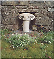
Old Milepost by the A6105, Foulden Deans, Foulden
Iron post by the A6105, in parish of Foulden (Berwick District), Foulden Deans, on grass verge against wall. Inscription reads:- : DUNS / 11 : : BERK. / 4 : Surveyed Milestone Society National ID: BD_BEDN04
Image: © Milestone Society Taken: Unknown
0.18 miles
5
Road through Foulden Deans
Looking along the A6105 as it passes through Foulden Deans. The milepost on the left of the photo states that Berwick is 4 miles to the east and that Duns is 11 miles to the west.
Image: © Graham Robson Taken: 10 Jul 2013
0.18 miles
6
Milepost at Foulden Deans
Milepost in Foulden Deans. Berwick is marked as 4 miles to the east, while Duns is 11 miles to the west.
Image: © Graham Robson Taken: 10 Jul 2013
0.18 miles
7
Road junction, Foulden
Travelling west on the A6105 through Foulden. The minor road to the right goes via Blinkbonny and Bastleridge (wonderful names!) to Ayton. The junction to the left gives access to housing in the Woodlands area.
Image: © Barbara Carr Taken: 14 May 2013
0.20 miles
8
Path alongside the A6105 in Foulden
There's a good broad path for pedestrians through Foulden, brightened in springtime by a joyous show of daffodils.
Image: © Barbara Carr Taken: 14 May 2013
0.21 miles
9
Field, Foulden
Arable field with a wide margin.
Image: © Richard Webb Taken: 26 Mar 2011
0.21 miles
10
A6105, Foulden
Looking east.
Image: © JThomas Taken: 27 Jul 2017
0.22 miles